Italiano
 Deutsch
Intorno al Cansiglio

Starting point for this itinerary is Fregona, from where we will travel along the belt road at the foot of the pre-Alps in the direction of Montaner. At the built-up area of Borgo Val we will climb to the left among the houses to reach the first ascent, which, with major rips on dirt and asphalt, leads to the 800 meters of Cima della Cima. A short stretch where we can take a rest and then continue the climb along the Strada del Patriarca (or dei Carbonai) until we join the via del Gaiardin at an altitude of 1000. At the left hairpin bend we leave the main road to plunge right into the beech forest on a pleasant forest road, recently paved, which then becomes gravel and concrete. In view of the first switchback at 1330 meters, the panorama becomes truly impressive, widening the view over gentle green bumps with the peaks of the Monte Cavallo group as a backdrop. From here, if it has not rained recently, it is possible to take a detour to casera Ceresera and walk a section of CAI path 991; if, on the other hand, the terrain does not permit the digression, simply continue rejoining the track in Candaglia.
Proceed following the Cansiglio ring in a long descent to the Valmenera pothole (900 meters) from where you go up to the locality of Pian Osteria, then proceeding on a track in the woods beside the main road, reaching in short locality Campon. Next destination is malga Mezzomiglio: with an ascent of 250 meters of elevation gain, once we reach the entrance to the Taffarel forestry road we ignore it, keeping to the right and following the signs for the malga, which is reached via ups and downs (and a steep ramp).
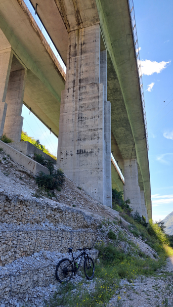
From malga Mezzomiglio (possibility of lavish refreshments in season and beyond), it's time to noticeably lose altitude on the long asphalt descent, which we abandon when in sight of S.Croce Lake to enter the woods and make the last stretch on dirt road -pretty shabby but cyclable- until we reach the road adjacent to the lake. We ride along the state road toward the Fadalto and leave it near the entrance to the quarry, which we will bypass by trail. Here a nice novelty: an ascent on gravel forestry to an elevation of 600 meters, then a descent (to my eye well short of traffic given the vigorous vegetation) that, having reached the pylons of the highway viaduct, continues for a long time keeping right under them. When you reach the case cantoniere, a thin track on the left allows you to rejoin the better-known detours that, keeping away from the highway, lead to Vittorio Veneto; via asphalt road you finally return to Fregona.