HOME RANKINGS CHALLENGES ROUTES NEAR ME PLANNING SEARCH LOGIN
Italy - Lombardia, BS
2022/10/16 13:32:29

Cima Comer, Eremo di San Valentino

37 Downloads
0
 
Share
Author
ValeBG
(147)
Place
Italy - Lombardia, BS
Km
26,12 km
Elapsed time
02:29:56
Vertical meters
+1 650 mt (66 - 1228)
Route difficulty
Landscapes
Last update
2025/03/18 08:46:39
Comments
2
Description

This is one of my favorite rides on the #garda! We park on a clearing in the road we continue on asphalt on comfortable inclines to the locality Sasso. Protectors on we descend a nice S2 trail and then join the road from Gargnano to Muslone, from Gargnano we take a nice trail (easy S1) that skirts the lake initially downhill then with several raises to the finish.

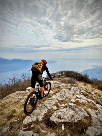
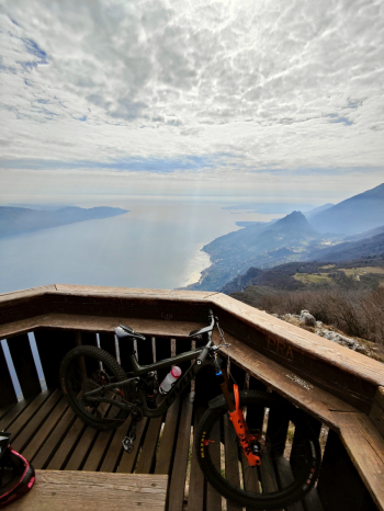
When you get to Piovere (last water point) you continue on asphalt with challenging inclines on little-to-no paved road. At an altitude of about 1000 the road becomes a path with 4 short deadly steeps. We continue always on trail and after about 70 meters on the shoulder we finally reach the top. Here there is a spectacular 360° panorama.

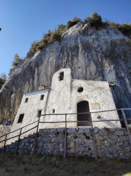
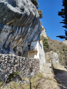
For the descent we tell about a variant that should not be too extreme and descends from the ridge but in this track we continue from the normal variant, We retrace the section made on the shoulder (70 meters of S4, the most technical of the descent) and then towards the hermitage of St. Valentine by a very technical and rocky path S3 medium (pay particular attention to a short section near the river quite exposed off the trail) Arrived at the junction for the hermitage of St. Valentine, you can visit it (you reach it on foot).

Immagine che contiene aria aperta, cielo, edificio, Rovine

Il contenuto generato dall'IA potrebbe non essere corretto.

Immagine che contiene aria aperta, cielo, pianta, albero

Il contenuto generato dall'IA potrebbe non essere corretto.

Continue on a less technical but still very physical mule track to Sasso, water point. Last nice S2 descent with some passages on the final S3+ and after a short ascent we are at the car.

Trail style: AM

Personal rating: views 9/10; Descents 9/10

MTB: yes

EMTB: yes

Duration about 5h by mtb

Portage: 70m (avoidable by leaving bikes behind)

Difficulty ascent: very challenging in places

Difficulty descent: S3

Exposed: Short section on trail however very wide

Drainage: ND

Download our free mobile app to send this route to your Garmin device or to navigate it on OSM maps. Android - iOS
Local weather
Today
17 °C
Tonight
11 °C
Tomorrow
21 °C
Tomorrow night
13 °C
Wednesday
20 °C
Wednesday night
11 °C
Thursday
19 °C
Thursday night
11 °C
Friday
20 °C
Friday night
12 °C

Graph

Nearest Routes

33,02 km
Km
+1 586 mt
Vertical meters
Route difficulty
Landscapes
2023/01/10
- Italy - Lombardia, BS
40,63 km
Km
+2 467 mt
Vertical meters
Route difficulty
Landscapes
2024/11/16
- Italy - Lombardia, BS
35,71 km
Km
+1 300 mt
Vertical meters
Route difficulty
Landscapes
2023/03/20
- Italy - Lombardia, BS
Padagiant
(9)
14,35 km
Km
+450 mt
Vertical meters
Route difficulty
Landscapes
2025/03/16
- Italy - Lombardia, BS
ValeBG
(147)
4,56 km
Km
+350 mt
Vertical meters
Route difficulty
Landscapes
2023/03/06
- Italy - Lombardia, BS
nonnocarb
(293)
42,22 km
Km
+1 530 mt
Vertical meters
Route difficulty
Landscapes
2023/12/11
- Italy - Veneto, VR
rfranz
(30)
18,82 km
Km
+700 mt
Vertical meters
Route difficulty
Landscapes
2024/06/10
- Italy - Veneto, VR
rfranz
(30)
26,18 km
Km
+870 mt
Vertical meters
Route difficulty
Landscapes
2023/07/26
- Italy - Veneto, VR
@ff.mtb
(9)
35,28 km
Km
+1 450 mt
Vertical meters
Route difficulty
Landscapes
2023/03/10
- Italy - Trentino-Alto Adige/Südtirol, TN
civi65
(106)
49,94 km
Km
+550 mt
Vertical meters
Route difficulty
Landscapes

2 Comments