
 Italiano
 Deutsch
Giro del Monte Tamaro

Itinerary around Mount Tamaro, with lots of trails, including uphill. I did it with the ebike, but it is also doable by bike as long as you have a good leg. Even with the ebike, fatigue is required because the elevation gain is so much and you'll have to conserve your battery. There are many fountains on the route.
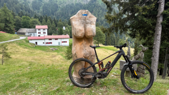
You start in Bioggio, in the industrial area, where there are parking lots at the Coop, which is closed on Sundays. It goes up to cademario via the Ronchi climb, then up to the trail that connects the village with Arosio. A gentle easy up and down. From Arosio you go up into the mountains and at the barrier you take a right to the Torricella Mountains, another trail with several ups and downs that are never technically challenging. Just before the Torricella Mountains you take a path to the left uphill that makes us start the ascent to the Alpe di Torricella: it is completely rideable, never really steep, and at the moment perfectly clean. This brings us to the road that leads first to Alpe di Torricella and then to Pian Cusello, with its famous wooden woman.
From here begins the final stretch of ascent to Bassa di Indemini: 400 meters of elevation gain first on a steep cart track/sentiero, and then on the trail that descends from Tamaro. This is hollowed out in places and the pedals touch the sods of grass, which is why an ebike helps to avoid having to go all the way around the pedals to get ahead. When we reach Bassa di Indemini, the panorama of the Lake Maggiore side opens up before us, while to our right the Tamaro looks slyly at us.
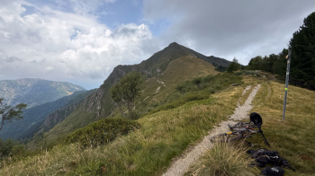
Now we have to get to Indemini, which is that little village you can see down here:
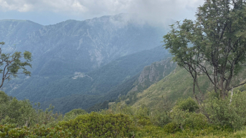
The path is initially narrow and partly hidden by vegetation, partly because there is a lack of pedestrians doing the Tamaro-Lema crossing this year because the Tamaro cable car is being rebuilt. Once you get to the Montoia Alp it widens and becomes much more fun, although there are a few passages to push through. The further down you go the more the trail becomes flowing, with some ups and downs that take us to the road up to Alpe di Neggia. It is 150 meters of elevation gain on asphalt. When we get to the pass (water) we take the famous Carbon Trail, kept very well this season (summer 2025) even though it is no longer an official bike trail.
Fast sections, rocky stretches, banked switchbacks and an uphill 100-meter drop climb rideable by ebike and only partly by bike bring us to Alpe di Trecciura, with a fantastic view of Lake Maggiore. A downhill section follows and then a very long flow traverse to the Vira di Sopra Mountains, another scenic spot. From here the descent resumes with a fantastic stretch, very flowing despite the never too tight hairpin bends, to arrive in Vira. Be careful when passing between houses, moderate your speed.
On the cantonal road and then on the bike path we arrive at Quartino, from where the last effort of the day starts, and that is the steep Roman road that takes us to the Monte Ceneri pass. From here, after a downhill stretch on the cantonal road to Rivera, we follow the Vedeggio bike path for about 17km to return to the starting point,
