Italiano
 Deutsch
Dal monte Tondo al passo di Romecchio

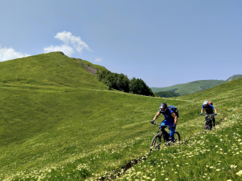
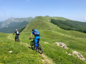
One of the most beautiful traverses of our Apennines, super panoramic, surrounded by fabulous scenery. The icing on the cake is the beautiful Cai 74 that from the Romecchio Pass closes this fantastic tour.For timing needs we started from Sillano, but my advice is to start from Metello to finish the tour with the descent from Romecchio and to enjoy a nice tagliere at the village trattoria. Recommended period October-November when the foliage reaches its peak.
From Sillano we follow the road to the Pradarena pass, but we leave it immediately above the village near the hairpin bend with signs for Ponteccio. We pass the villages of Dalli di sotto and sopra until we reach Ponteccio and immediately after passing it we turn left onto the long forest road that leads to the Monte Tondo Refuge.Once at the refuge we continue on a path that is initially steep, but once we reach the foot of Tondo it becomes rideable again. If you want with a short bike ride you can reach the summit and descend on the opposite side, totally cyclable, taking the path again, but considering the length of the tour we prefer to pull ahead.
The path alternates in an up and down until the Passo del Gatto where you need to carry your bike carefully to overcome an exposed rock jump. The next section should always be tackled by loading your bike on your shoulders or on your side for about a hundred meters after which you can ride again until the beginning of the short, very fun downhill section that ends on the roadway leading to the Pradarena pass.
From the latter, just cross the road to continue on the watershed path that we will never leave until we reach the Romecchio Pass. This is the most scenic and beautiful section of the entire tour where we still have to alternate between a few pushing stretches but not necessarily with bikes on our backs. Once past the top of the Porraie finally begins a fantastic descent that together with the Cai 74 leads us to the village of Metello.