HOME RANKINGS CHALLENGES ROUTES NEAR ME PLANNING SEARCH LOGIN
Italy - Lombardia, BG
2025/06/03 23:05:58

Rifugio Alben (versione facile)

0 Downloads
0
 
Share
Author
ValeBG
(155)
Place
Italy - Lombardia, BG
Km
16,14 km
Elapsed time
01:46:48
Vertical meters
+900 mt (881 - 1612)
Route difficulty
Landscapes
Last update
2025/06/04 07:35:41
Comments
0
Description

This tour is proposed to those who would like to ride under the Alben's cospect without the search for too challenging descents, In this track the proposed climb is from Cornalba on a road specially arranged for Emtb the slope is very high (20/25%), in mtb I suggest to follow the climb from Serina (see variants below).

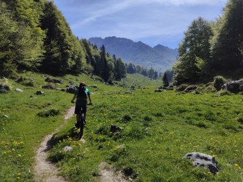
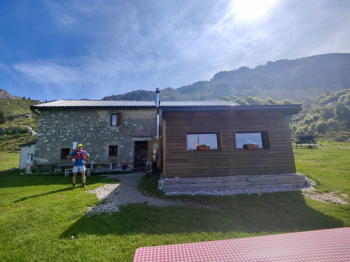
Arrived at the Alben refuge (Emtb recharge point) continue from very nice and not difficult flat traverse to the Sappli Pass. From the pass there is the most technical part of the tour, the trail is becomes a technical "forced" descent about 80m very technical S4 and 80m S2/S3. Then it goes back to being an easy S2 traverse to Pian della Mussa. The tour continues on never too complex and very fun trails to Serina and then to return to Cornalba


Uphill variants:

By mtb climb from Serina this trail.

Other variants

Ascent to Mount Alben

Ascent to Brassamonti Pass and Cima monte Croce peak


Descent variants.

Technical S4 descent from Sappli Pass this trail

Bad and ill-advised technical S4 descent from Brassamonti Pass this track

Technical descent S4 from su Cornalba this track


Trail Style: Enduro/All mountain

Personal rating: views 7/10; descents 8/10

MTB: Yes

EMTB: Yes

Duration about 4h (in mtb)

Portage: 500m if in mtb

Difficulty ascent: challenging in mtb

Difficulty descent: almost all S1/S2

Exposed: No

Drainage: ND

Water points: Alben Refuge


Download our free mobile app to send this route to your Garmin device or to navigate it on OSM maps. Android - iOS
Local weather
Today
23 °C
Tonight
17 °C
Tomorrow
23 °C
Tomorrow night
17 °C
Sunday
26 °C
Sunday night
16 °C
Monday
23 °C
Monday night
16 °C
Tuesday
25 °C
Tuesday night
16 °C

Graph

Nearest Routes

2025/06/03
- Italy - Lombardia, BG
ValeBG
(155)
13,17 km
Km
+900 mt
Vertical meters
Route difficulty
Landscapes
2025/06/03
- Italy - Lombardia, BG
ValeBG
(155)
25,06 km
Km
+1 650 mt
Vertical meters
Route difficulty
Landscapes
2024/04/05
- Italy - Lombardia, BG
Maxone1
(10)
20,71 km
Km
+850 mt
Vertical meters
Route difficulty
Landscapes
2025/06/03
- Italy - Lombardia, BG
ValeBG
(155)
22,82 km
Km
+1 350 mt
Vertical meters
Route difficulty
Landscapes
2023/08/11
- Italy - Lombardia, BG
ValeBG
(155)
29,29 km
Km
+1 400 mt
Vertical meters
Route difficulty
Landscapes
2022/10/10
- Italy - Lombardia, BG
paiogs
(12)
31,56 km
Km
+2 400 mt
Vertical meters
Route difficulty
Landscapes
2023/05/27
- Italy - Lombardia, BG
ValeBG
(155)
7,18 km
Km
+280 mt
Vertical meters
Route difficulty
Landscapes
2025/03/16
- Italy - Lombardia, BG
ValeBG
(155)
27,67 km
Km
+1 150 mt
Vertical meters
Route difficulty
Landscapes
2025/03/17
- Italy - Lombardia, BG
ValeBG
(155)
29,47 km
Km
+1 350 mt
Vertical meters
Route difficulty
Landscapes
25,25 km
Km
+1 268 mt
Vertical meters
Route difficulty
Landscapes

0 Comments