
 Italiano
 Deutsch
2025/04/28 16:36:06
Soca Flow
Author
Place
Slovenia
Km
19,38 km
Elapsed time
02:51:14
Vertical meters
+639 mt (101 - 667)
Route difficulty
Landscapes
Last update
2025/04/28 16:40:42
Comments
Description
Asphalt ascent from the center of Kanal with consistently moderate gradients.
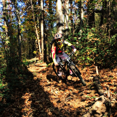
Blue trail with classic Slovenian-style steeps, mostly smooth terrain with roots in places.
Local weather

°C
°C
°C
°C
°C
°C
Graph
Nearest Routes
2023/06/26
- Italy - Friuli-Venezia Giulia, UD 36,67 km
Km
+1 200 mt
Vertical meters
Route difficulty
Landscapes
30,90 km
Km
+1 212 mt
Vertical meters
Route difficulty
Landscapes
55,90 km
Km
+1 560 mt
Vertical meters
Route difficulty
Landscapes
27,02 km
Km
+960 mt
Vertical meters
Route difficulty
Landscapes
26,55 km
Km
+690 mt
Vertical meters
Route difficulty
Landscapes
22,15 km
Km
+650 mt
Vertical meters
Route difficulty
Landscapes
59,81 km
Km
+810 mt
Vertical meters
Route difficulty
Landscapes
31,32 km
Km
+830 mt
Vertical meters
Route difficulty
Landscapes
20,75 km
Km
+1 100 mt
Vertical meters
Route difficulty
Landscapes
32,72 km
Km
+1 500 mt
Vertical meters
Route difficulty
Landscapes