
 Italiano
 Deutsch
2025/02/17 11:12:14
Alpe Meden
Author

Place
Italy - Lombardia, SO
Km
17,94 km
Elapsed time
00:00:00
Vertical meters
+973 mt (1563 - 2432)
Route difficulty
Landscapes
Last update
2025/02/17 11:35:57
Comments
Description
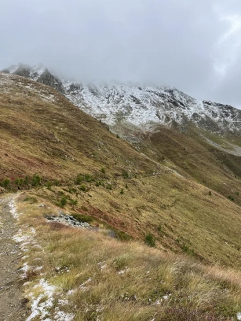
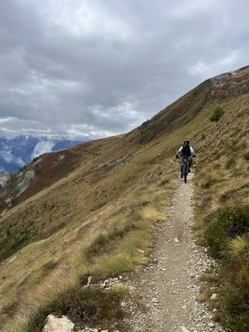
Valtellina or Tibet? As you can see from the photos the Meden Alp is truly a mystical place, the trail that connects the ski slopes to the Meden Hut is almost entirely at high altitude, with some steep climbs up to the hut at 2427 meters. This is a trail for experts because of the roughness of the trail in some sections and some rather steep climbs. We believe it is a trail that all bikers should try at least once in their lives.
Local weather

°C
°C
°C
°C
°C
°C
Graph
Nearest Routes
9,97 km
Km
+585 mt
Vertical meters
Route difficulty
Landscapes
14,94 km
Km
+757 mt
Vertical meters
Route difficulty
Landscapes
14,84 km
Km
+429 mt
Vertical meters
Route difficulty
Landscapes
12,50 km
Km
+457 mt
Vertical meters
Route difficulty
Landscapes
17,23 km
Km
+927 mt
Vertical meters
Route difficulty
Landscapes
26,36 km
Km
+625 mt
Vertical meters
Route difficulty
Landscapes
42,99 km
Km
+2 000 mt
Vertical meters
Route difficulty
Landscapes
51,85 km
Km
+2 100 mt
Vertical meters
Route difficulty
Landscapes
2023/11/24
- Italy - Lombardia, SO 53,32 km
Km
+2 220 mt
Vertical meters
Route difficulty
Landscapes
99,74 km
Km
+3 036 mt
Vertical meters
Route difficulty
Landscapes