HOME RANKINGS CHALLENGES ROUTES POI PLANNING SEARCH LOGIN
Italy - Trentino-Alto Adige/Südtirol, BZ
2024/08/22 19:11:35

Forcella di Laces

5 Downloads
0
 
Share
Author
nonnocarb
(287)
Place
Italy - Trentino-Alto Adige/Südtirol, BZ
Km
74,92 km
Elapsed time
07:08:14
Vertical meters
+2 500 mt (299 - 2517)
Route difficulty
Landscapes
Last update
2024/08/22 22:21:24
Comments
0
Description

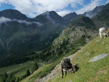
The Laces Fork divides the Ultimo valley from the Venosta valley. The ascent, from Merano, is long and challenging, pedaling up to Lake Quaira at 2200 meters, then the last 300 are a push with a section of bike backpacking. In return, the high mountain environment is spectacular.

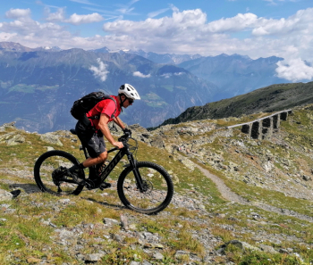
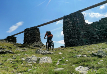
At the top, at an elevation of 2520, in addition to the view of the Alps bordering Austria, we can admire a true work of art, what remains of Europe's highest irrigation canal, used in past centuries to bring water 2000 meters lower, as the Vinschgau Valley is, and always has been, the driest in South Tyrol, with more than 300 days of sunshine a year and little precipitation.

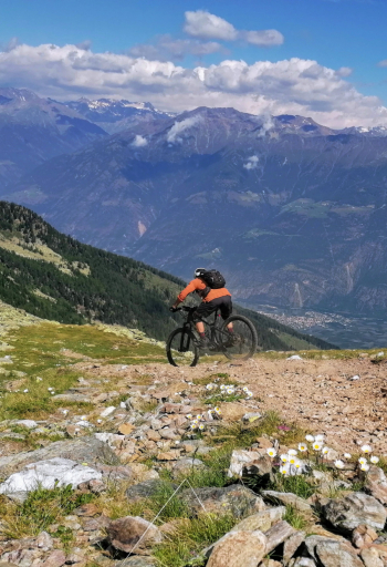
And just as the water descended 2000 meters, our descent is long, very long! And also very challenging, first a beautiful high mountain trail but with sections to be done on foot, then the Barbarossa Trail, always beautiful, ending with the Roatbrunn Trail, which used to be easier, but now is so rocky that it's a real kick in the pants at the end, assuming you can make it to the bottom!

In short, for those in the know there is fun to be had, for others you have to have good shoes! Back on the bike path (or train) to Merano.

Download our free mobile app to send this route to your Garmin device or to navigate it on OSM maps. Android - iOS
Local weather
Oggi
18 °C
Stasera
14 °C
Domani
18 °C
Domani sera
15 °C
domenica
22 °C
Domenica notte
14 °C
lunedì
22 °C
Lunedì notte
13 °C
martedì
21 °C
Martedì notte
12 °C

Graph

Nearest Routes

2024/08/25
- Italy - Trentino-Alto Adige/Südtirol, BZ
nonnocarb
(287)
61,04 km
Km
+2 300 mt
Vertical meters
Route difficulty
Landscapes
2022/10/22
- Italy - Trentino-Alto Adige/Südtirol, BZ
nonnocarb
(287)
65,78 km
Km
+2 336 mt
Vertical meters
Route difficulty
Landscapes
2022/11/21
- Italy - Trentino-Alto Adige/Südtirol, BZ
nonnocarb
(287)
41,95 km
Km
+1 783 mt
Vertical meters
Route difficulty
Landscapes
2023/03/05
- Italy - Trentino-Alto Adige/Südtirol, BZ
nonnocarb
(287)
31,25 km
Km
+1 100 mt
Vertical meters
Route difficulty
Landscapes
2023/03/02
- Italy - Trentino-Alto Adige/Südtirol, BZ
nonnocarb
(287)
51,00 km
Km
+1 610 mt
Vertical meters
Route difficulty
Landscapes
2024/08/22
- Italy - Trentino-Alto Adige/Südtirol, BZ
nonnocarb
(287)
64,04 km
Km
+2 200 mt
Vertical meters
Route difficulty
Landscapes
2024/09/18
- Italy - Trentino-Alto Adige/Südtirol, BZ
nonnocarb
(287)
59,35 km
Km
+3 050 mt
Vertical meters
Route difficulty
Landscapes
2023/03/01
- Italy - Trentino-Alto Adige/Südtirol, BZ
nonnocarb
(287)
76,06 km
Km
+2 300 mt
Vertical meters
Route difficulty
Landscapes
2024/10/10
- Italy - Trentino-Alto Adige/Südtirol, BZ
Staff
(75)
29,33 km
Km
+1 650 mt
Vertical meters
Route difficulty
Landscapes
2023/03/01
- Italy - Trentino-Alto Adige/Südtirol, BZ
nonnocarb
(287)
53,70 km
Km
+1 570 mt
Vertical meters
Route difficulty
Landscapes

0 Comments