Pale di San Martino
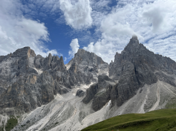
Spectacular tour around and through, the Pale di S.Martino. This version involves the use of an ebike and uses two lifts to complete the loop (S.Martino di Castrozza - Rosetta about 1000 meters of elevation gain). Here the alternative version with regular bike. You start from Cencenighe (I started from Alleghe and via secondary roads and bike paths I reached Cencenicghe) and go up to Canale d'Agordo following the forestry road (recently fixed) beside the Biois stream and up to Canale the climb is very gradual.Then proceed to Caviola/Falcade; the climbs become more intense but the forest road is well tracked even after Caviola (last year it was being set up) to Falcade.
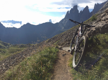
Here you reach the gondola (Molino locality) and take a forest road that climbs along the slopes, but has a medium gradient except for a few tears. Shortly after Hotel Dolomiti take a left onto the forest road that will take us to Passo Valles without a meter of asphalt. The slope in the first section is gradual but then there are a couple of hard (rideable) tears and you reach the alpine pastures below Passo Valles. The path over the alpine pastures is marked but has an uneven surface on the grass that makes the ascent very hard. The last section becomes well rideable again until the pass. Here begins a steep climb (Cai 749) to Forcella Valles (first section on dirt and then rock; several sections with push bikes). From the fork, descent to the Venegia valley via Cai 749 and then via a left-hand variant that retraces old military roads. Very trialistic section on dirt/grass and rocks, then you rejoin 749 at the lower end; the second section is a faster trail to the Val Vengia cart track.
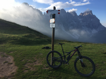
You arrive in the beautiful Val Vengia and climb up a long but gradual dirt road to Baita Segantini. From here to descend to Passo Rolle you must follow the dirt road (the old single track is now a gravel road closed to bikes), with only a final section (technical steep) just above the provincial road of Passo Rolle (this year I eliminated the section towards the Laghetti di Colbricon as the access road is also closed to bikes and would have to be ridden by hand bike).
After a short stretch of asphalt toward San Martino, near an alpine hut you take a small road (ciclovia) on the left that descends to San Martino avoiding the asphalt; nothing much but still better than asphalt. In the second part, the small road continues with hairpin bends that are always very flowing. At a fork you climb back up to follow the Orti forestali sign. At the end of the little climb (well pedalable) the descent to San Martino begins, a fun single track (wider in places) with hairpin bends and non-trivial technical passages, over pebbles and rocks, and you arrive at Pra delle Nasse in San Martino (respect the bike bans).A short ride to S.Martino and then up to the start of the Col Rosetta cable car.
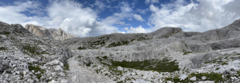
You can take the two lifts or bike up to the cable car (but for 5? difference it is not worth it). Arriving at the top station, a descent of about 2000 meters of elevation gain awaits us! Wide path over rock, with a few more technical passages up to Rosetta (watch out for numerous pedestrians). From here we take the military mule track cai 746 and begin the crossing of the great Pale plateau. The trail is perfectly maintained, wide and with a stony bottom, but well rideable and has a series of ups and downs for the first section; some slightly exposed sections and trialistic passages on the rocky cliffs in the middle section.Then at a fork you go straight (and not left) and ascend in the direction of Malga Campigat. A climb up a military road (short push pass) a saddle and then a spectacular rock amphitheater with the mule track that runs along it. There are no particular technical difficulties, only an overhang to the left that is not very reassuring; the mule track is never narrower than 1 meter (watch out that a section of a couple of meters is landslide and the passage must be done carefully).
You come to an earth path and a very fun forest road begins (among the low vegetation) with a very flowing earth bottom and a long series of wide hairpin bends (also here a couple of landslides to be done with care). Watch out for a small path to the left in view of Malga Campigat and in a short time you arrive at the malga/bivouac. Here you descend (forcella Cesurete) taking a small path to the left and the descent to Gares begins. First technical section with dirt steps and wooden ladders (very technical, but rideable and recently fixed) and then you join the path coming from Malga Valbona and take a right. From here the descent becomes faster, dirt bottom with a series of beautiful hairpin bends on dirt and pine needles, but also technical passages, steps, roots and rocks of all respect.
You arrive at the large parking lot in Gares, brief stop at the fountain and then along a nice, restful forest road (all slightly downhill) down the long valley of Gares to Canale d'Agordo. Here you take the dirt road that runs along the river (to the right) and descends to Cencenighe (section traveled in the morning). In the final section you cross to the other bank and take the bike path or tunnel and arrive in Cencenighe and by the same route already taken, to Alleghe (but uphill).


 Italiano
 Deutsch