2024/08/12 20:49:45
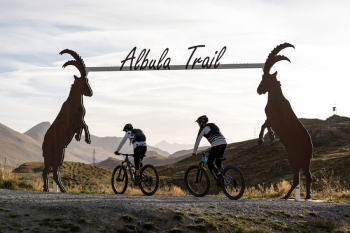
La Punt-Albulapass-Es-cha rifugio-Madulain
Author
Place
Switzerland
Km
26,02 km
Elapsed time
00:00:00
Vertical meters
+1 005 mt (1679 - 2593)
Route difficulty
Landscapes
Last update
2024/08/13 18:22:55
Comments
Description
Fun on the trail must be gained first, climbing the pass road to Albula Pass, the beginning of the Albula Trail. This is walked until about halfway up, before the Muntisché Trail leads to the Chamanna d'Es-cha on the left. The hut invites you to take a break with its magnificent view of the Bernina range and its culinary specialties. A break is definitely a plus, because the descent to Madulain is technically challenging. Once you have descended to Madulain, you return to La Punt.
You can go up to the pass by Bus Alpin.

Local weather
Today

20 °C
Tonight

7 °C
Tomorrow

23 °C
Tomorrow night

9 °C
Tuesday

22 °C
Tuesday night

10 °C
Graph
Nearest Routes
38,27 km
Km
+695 mt
Vertical meters
Route difficulty
Landscapes
34,63 km
Km
+1 038 mt
Vertical meters
Route difficulty
Landscapes
62,40 km
Km
+2 104 mt
Vertical meters
Route difficulty
Landscapes
39,96 km
Km
+1 600 mt
Vertical meters
Route difficulty
Landscapes
29,54 km
Km
+1 300 mt
Vertical meters
Route difficulty
Landscapes
53,29 km
Km
+2 000 mt
Vertical meters
Route difficulty
Landscapes
21,58 km
Km
+1 316 mt
Vertical meters
Route difficulty
Landscapes
34,96 km
Km
+1 430 mt
Vertical meters
Route difficulty
Landscapes
75,05 km
Km
+1 900 mt
Vertical meters
Route difficulty
Landscapes
81,68 km
Km
+2 410 mt
Vertical meters
Route difficulty
Landscapes


 Italiano
 Deutsch