HOME RANKINGS CHALLENGES ROUTES POI PLANNING SEARCH LOGIN
Italy - Valle d'Aosta, AO
2024/07/30 22:30:48

Testa di Liconi da Morgex

4 Downloads
0
 
Share
Author
ValeBG
(137)
Place
Italy - Valle d'Aosta, AO
Km
24,02 km
Elapsed time
08:08:45
Vertical meters
+2 100 mt (925 - 2924)
Route difficulty
Landscapes
Last update
2024/08/01 14:21:04
Comments
0
Description

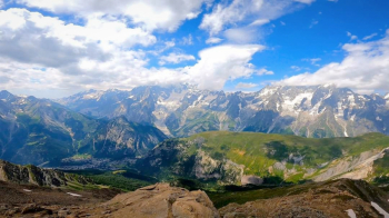
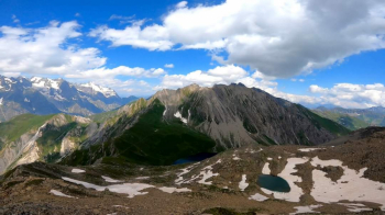
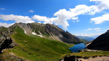
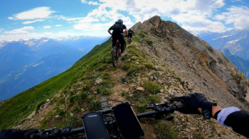
Extremely challenging but extremely beautiful tour, extraordinary views with views of Mont Blanc and descent from 2000 meters of elevation gain that is never trivial. Departure from Morgex with the first part all pedal to Liconi, climb with constant and continuous gradient (more than 10%). Once in Liconi fill up with water because 1100 meters of elevation gain await you by carrying and pushing the bike. Climb up to Lake Prima, after which there are a few points where you pedal during the ascent to Liconi Pass, from here the view opens to the Mont Blanc chain and all the nearby peaks. Last climb to the head, about 300 meters, very challenging with bike on shoulder.


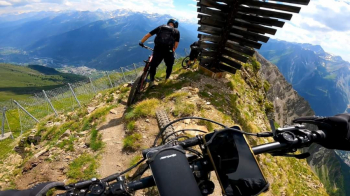
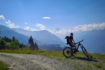
Depart downhill from Pascal bivouac, aim immediately at the avalanche barriers, there is actually a path that goes through it, unfortunately we did not see it and went from below, missing however the only bikeable point of the avalanche barriers traverse. Past the avalanche barriers starts a beautiful, steady but never trivial single track. The trail is always on grassy meadows that are often very steep and exposed, so maximum attention. You then enter the woods and it gets even more mouthwatering. You end up on a driveway, keeping left to return to Morgex.

Track and description by FabioCape, photos and video by MarcelloA.


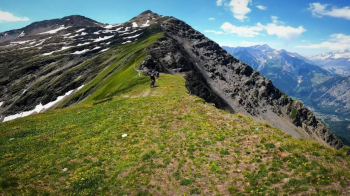
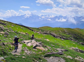
Rating : panoramas 10/10; descents 9/10

Descent difficulty

MTB: yes

EMTB: not recommended (although there are those who have done it by emtb)

Elevation gain: 2100

Duration: about 9h

Exposed: See description

Drainage: ND

Water points: Only water found near the end at a cabin before the last piece in the woods.

Download our free mobile app to send this route to your Garmin device or to navigate it on OSM maps. Android - iOS
Local weather
Today
16 °C
Tonight
8 °C
Tomorrow
15 °C
Tomorrow night
8 °C
Thursday
13 °C
Thursday night
8 °C
Friday
14 °C
Friday night
7 °C
Saturday
11 °C
Saturday night
7 °C

Graph

Nearest Routes

2023/07/24
- Italy - Valle d'Aosta, AO
gabryel87
(1)
287,59 km
Km
+7 127 mt
Vertical meters
Route difficulty
Landscapes
2022/08/06
- Italy - Valle d'Aosta, AO
gmzolenart
(113)
35,06 km
Km
+1 738 mt
Vertical meters
Route difficulty
Landscapes
2024/07/15
- Italy - Valle d'Aosta, AO
marco
(127)
49,47 km
Km
+2 300 mt
Vertical meters
Route difficulty
Landscapes
2024/07/15
- Italy - Valle d'Aosta, AO
marco
(127)
55,58 km
Km
+2 546 mt
Vertical meters
Route difficulty
Landscapes
2023/06/09
- Italy - Valle d'Aosta, AO
gmzolenart
(113)
26,81 km
Km
+1 600 mt
Vertical meters
Route difficulty
Landscapes
2023/06/24
- Italy - Valle d'Aosta, AO
Tommy s.
(3)
8,84 km
Km
+347 mt
Vertical meters
Route difficulty
Landscapes
2023/07/09
- Italy - Valle d'Aosta, AO
55,04 km
Km
+2 888 mt
Vertical meters
Route difficulty
Landscapes
2022/08/07
- Italy - Valle d'Aosta, AO
gmzolenart
(113)
30,55 km
Km
+1 111 mt
Vertical meters
Route difficulty
Landscapes
2023/10/14
- Italy - Valle d'Aosta
16,80 km
Km
+900 mt
Vertical meters
Route difficulty
Landscapes
2023/11/11
- Italy - Valle d'Aosta, AO
43,95 km
Km
0 mt
Vertical meters
Route difficulty
Landscapes

0 Comments