HOME RANKINGS CHALLENGES ROUTES POI PLANNING SEARCH LOGIN
Italy - Trentino-Alto Adige/Südtirol, BZ
2024/06/06 18:10:30

Montagna del Ferro

6 Downloads
0
 
Share
Author
Place
Italy - Trentino-Alto Adige/Südtirol, BZ
Km
30,63 km
Elapsed time
00:00:00
Vertical meters
+1 400 mt (1315 - 2646)
Route difficulty
Landscapes
Last update
2024/06/07 08:29:25
Comments
0
Description

Extreme ride only for extreme enthusiasts.

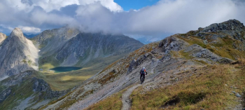
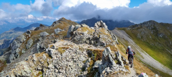
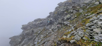
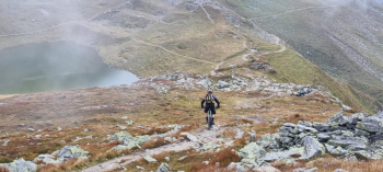
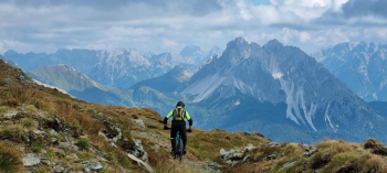
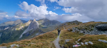
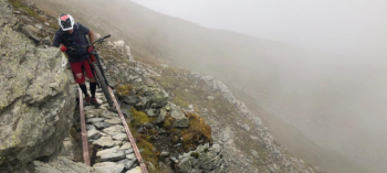
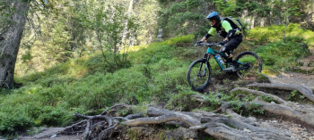
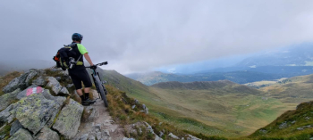
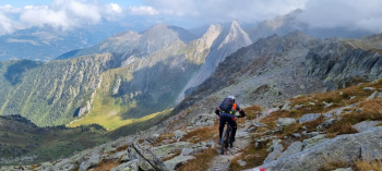
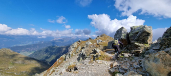
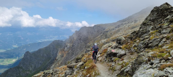
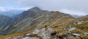
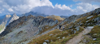
Starting at Mount Elmo, we cross it on a challenging but never extreme dirt road in the direction of Iron Mountain. Begin a singletrack almost always on endless aerial ridge, always pedaling over 2500 meters altitude, often passing over Austrian territory, and on the line of WWI trenches and forts. Technical climbs and descents, on part of the famous STONEMANTRAIL, and the Demut Trail. Upon reaching the Nems Saddle instead of descending on the Demut Trail, we continue by bike on the backpacking trail with climbing passages and small, very exposed iron bridges. Past Montagna Del Ferro follows a first part of descent, technical , exposed, on challenging alpine trail and rockgarden, glimpses of highland lakes and valleys until we reach Sella dei Frugnoni. Second descent on an old military trail full of switchbacks to Silvella Pass. Here a non-trivial pastoral trail, with trialistic relaunches, and descents made challenging by large roots, to the alpine hut below where you can refresh yourself. A short dirt road, and then a small ascent to reach the entrance of the Erla Trail, a trail in the underbrush with switchbacks and challenging steeps, passages over roots and steps to Moso.

Done in September 2021.

NB: not recommended for those unaccustomed to high mountains and exposed passages in with backpacking bikes and small but difficult climbs.


Download our free mobile app to send this route to your Garmin device or to navigate it on OSM maps. Android - iOS
Local weather
Today
21 °C
Tonight
11 °C
Tomorrow
16 °C
Tomorrow night
7 °C
Tuesday
18 °C
Tuesday night
8 °C
Wednesday
16 °C
Wednesday night
8 °C
Thursday
10 °C
Thursday night
3 °C

Graph

Nearest Routes

2023/03/08
- Italy - Trentino-Alto Adige/Südtirol, BZ
civi65
(103)
30,41 km
Km
+1 000 mt
Vertical meters
Route difficulty
Landscapes
2022/09/17
- Italy - Trentino-Alto Adige/Südtirol, BZ
steve-U
(23)
41,63 km
Km
+1 879 mt
Vertical meters
Route difficulty
Landscapes
2023/02/26
- Italy - Trentino-Alto Adige/Südtirol, BZ
nonnocarb
(284)
24,89 km
Km
+790 mt
Vertical meters
Route difficulty
Landscapes
2023/03/06
- Italy - Trentino-Alto Adige/Südtirol, BZ
nonnocarb
(284)
29,85 km
Km
+1 700 mt
Vertical meters
Route difficulty
Landscapes
2023/02/26
- Italy - Trentino-Alto Adige/Südtirol, BZ
nonnocarb
(284)
22,50 km
Km
+850 mt
Vertical meters
Route difficulty
Landscapes
2023/02/26
- Italy - Trentino-Alto Adige/Südtirol, BZ
nonnocarb
(284)
17,34 km
Km
+1 000 mt
Vertical meters
Route difficulty
Landscapes
2023/03/07
- Italy - Trentino-Alto Adige/Südtirol, BZ
nonnocarb
(284)
44,46 km
Km
+1 400 mt
Vertical meters
Route difficulty
Landscapes
2023/03/01
- Italy - Trentino-Alto Adige/Südtirol, BZ
nonnocarb
(284)
135,06 km
Km
+3 800 mt
Vertical meters
Route difficulty
Landscapes
2023/09/01
- Italy - Trentino-Alto Adige/Südtirol, BZ
47,62 km
Km
+1 550 mt
Vertical meters
Route difficulty
Landscapes
2023/03/02
- Italy - Trentino-Alto Adige/Südtirol, BZ
civi65
(103)
43,07 km
Km
+1 550 mt
Vertical meters
Route difficulty
Landscapes

0 Comments