
 Italiano
 Deutsch
Piz Umbrail

[Report by Marzia Fioroni] It had been about 12 months that Muldox, at first sporadically, then more and more insistently, had been asking to accompany him on an expedition, which he said would become part of history: the conquest of Piz Umbrail (3,033 m), a border peak between Italy and Switzerland not far from the Stelvio Pass.
If for the first 300 days Niccolò, Zergio and I responded elusively, postponing our participation in the adventure to undefined ?better times? , in the last period the excuses were increasingly difficult to invent. Work justifications, unavoidable family commitments, sudden allergic reactions were no longer enough: Muldox had even set up a tent five feet from my front door and immediate action had to be taken. With a quick round of e-mails the date had thus been chosen: August 14 (so as not to preclude participants from a successful tour at least for the following day, i.e., Ferragosto).
Already, because we were not even hiding the doubt that gripped us more than a little: that of the crazy ravine. Why until now had the MTB world left Piz Umbrail out of its cards? Why was there no trace of any previous exploration to be found? The possible catastrophic outcome of the affair, needless to say, worried everyone except The Sheriff, who was at the rendezvous site well in advance on the morning of the rendezvous, his best uniform and a big-ticket smile. Zergio had taken it a little worse and the previous evening had well thought of annihilating his anxiety with grappini, thus arriving late, pale and desperately asking for an aspirin, according to him the panacea of all ills. Niccolo, on the other hand, had had to strain his family relationships to be there, and was showing obvious signs of being beaten. And then there was me, who was still not well awake (as usual) and harbored only the vain hope of not really suffering too much. Having disassembled and reassembled the pieces of 4 people and 4 bicycles from one car, all that was left was to let fate take its course.
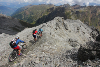
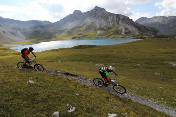
The fine air of the high altitudes, at any rate, was helping to clear everyone's thoughts, and a modicum of optimism was beginning to waft through the group. The grandiose scenery of the Ortles Mountains was only a stone's throw away, as were the more famous routes of the Upper Rhaetian: there across the way, Bocchetta Forcola was just coming alive with a growing number of morning bikers. At the nods of astonishment of the hikers on foot who saw the group heading determinedly toward the high altitudes, at times pedaling, at times biking, they pretended not to mind, also because after all it was not the first time they had faced the ascent to a peak, putting into account more than 500 m of difference in altitude roughly on foot. The path of the rest climbed uncovering only part of the route, thus still leaving several unknowns about the future, and especially about the slope that would host the descent, the northern one. All in all, apart from a somewhat challenging passage having the bike in tow, the group was proceeding serenely, and even Zergio and Niccolò were beginning to look enthusiastic about the choice: scenarios like this are not seen so often!
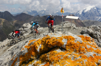
And the scenery from the summit left even the chirpy Lo Sceriffo speechless and breathless, who was happier than ever, rubbing his hands together anticipating, frothing at the mouth, the long descent that was looming, and which he had wittily guessed from reading and rereading maps of the area. To further prove his victory, he was even seen nose to the ground to assess whether there were any prior tire tracks at the site! One last adjustment to the tire pressure, four superstitious gestures, and off he went! The adventure, the real one, could begin.
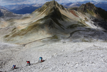
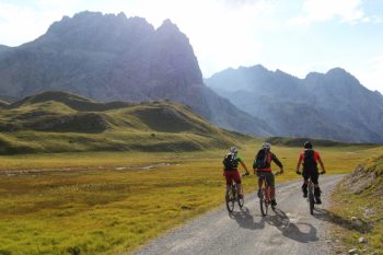
From the very first meters it seemed like the ideal descent, the one tailor-made for fat wheels, even though it was created for quite different purposes. Projecting toward the valley, as if suspended in time, a satisfying taste of happiness pervaded the foursome, leaving only time for Zergio to exclaim after a burp, "erda, what a trail!" Every meter, every bend a new discovery, an unexpected perspective, a particular light that rapt. The single-track continued to flow flawlessly, always different from itself, but always exciting and engaging. Rims Lake seen from above, with the lights of a late afternoon, I'll just let you imagine! One last dip toward the Mora Valley still hid curves and bends, jumps, hops and jumps. For those who could do them. All along the way several cows, but no bipeds on the horizon. Unbelievable: with a trail like this, it was to be expected on the most beautiful spot a ticket collector to collect his obolus. But instead nothing, just us around!
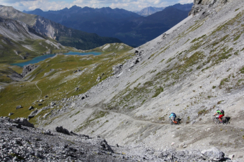
We leave Laj da Rims behind to face the last unknown: the steep crags that will allow us to reach Val Vau. From there we will ascend into Val Mora and, via the pass of the same name, reach the Cancano dams before finally gliding over Bormio along one of the many possible trails (Ferrarola strongly recommended). What were the dreaded crags like? As anthology-like as everything else, both for the environment and for the singletrack that, with a mix of flow and switchbacks, allows you to overcome them without having to walk a single meter.
We did the climb from Bormio to the Umbrail Pass by car but it is easily pedaled on the legendary Stelvio climb, or avoided with the bus service that leaves from Bormio.
