Via degli Dei giorno 1
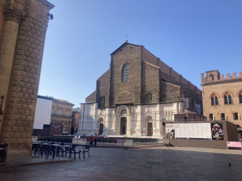
It is from the center of the city of Bologna that this itinerary starts, which my partner and I have decided to travel in 3 days from Bologna to Florence in the footsteps of the Medici, crossing our beautiful Apennines. Some important clarifications: I will not slavishly report all the stages with an abundance of photos of every single step because on the web you can find a lot of these reports and there is also a dedicated site but I will simply report the route we took net of all the detours and modifications both due to the landslides that have affected these areas in recent weeks and due to the fact that the route is born to be covered on foot and therefore some sections are not viable in Mtb; equipped with an analog map and the app walk+ that I recommend to everyone because it is precise full of information and well done we started as custom requires from Piazza Maggiore in the direction of Madonna di S. Luca alongside the world's longest portico on the first asphalt climb of our trip.
Once we departed from S. Luca we headed for Talon Park and here the first detours begin due to landslides or closed portions of the trail, in part the route is diverted onto the Via della Lana e Seta, once at the park the route winds its way through the maze of pleasant paths that lead up to Palazzo Rossi, from there we continue on asphalt to the loc. Ganzole where the trail is again closed and we climb a rather steep asphalt and then off-road climb that leads up to Monte del Frate and then to Brento; also here further detour that should have been reopened these days.
After the lunch stop we resume on asphalt and in small part off-road the way to Tre fasci and Monzuno and then continue on similar terrain are to Monte del Galletto and then descend to Madonna dei Fornelli end of our first stage.


 Italiano
 Deutsch