Italiano
 Deutsch
Sparviero, Rosello, Colma di San Glisente
I could call it a "grand flower cycle-hiking tour" because of the overbearing bloom present, it certainly is a long ride through beautiful and scenic mountains. It surprised me too, I thought it could be a nice ride, beautiful mountains but nothing striking. Instead it was amazing. It may be the bloom, the freshness of the bright green, the views, the trails.
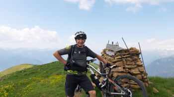
The highest elevation is the Colma di S. Glisente, 2160 meters, a spectacular vantage point. The view sweeps from the Adamello Group, to the Orobie, Bernina, and the pre-Alps of Bergamo and Brescia with Guglielmo in the background. You can also see a section of the Valle Camonica valley furrow and a glimpse of Lake Iseo.
It is also a tough ride, with the long, very steep initial climb (I admit, for nice stretches I pushed but it was necessary to safeguard my legs a bit, with the regular bike). Several push sections along the trails with a few shoulder sections, the most challenging the one from the niche of S. Glisente to the ridge of Mt. Fra, a hundred meters of elevation gain in all. The descent follows a local track, mostly very beautiful, with super technical, challenging trails and a few wild sections, on thin tracks or even without, where you have to keep an eye on the gps track.
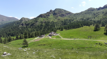
Start from Montecchio, elevation about 200 meters, a hamlet of Darfo Boario Terme (large parking lot by the parish church). From the nearby small hamlet of Fucine the very steep Cervera climb begins. Very difficult, if not impossible to pedal it all (with a normal bike). At the Crist chapel keep to the left and continue the climb to malga Piazza la Nera, elevation about 1680 meters.
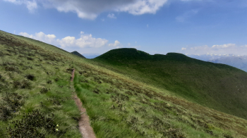
From here take a path in the Meadow on the right that leads to Dosso Sparviero, elevation 1893 meters. Now descend, spotting the path on the left, and then ascend slightly on the ridge, following the path that leads to malga Paglia. Shortly, on a cartroad, you reach Stanga del Bassinale, elevation 1897 meters.
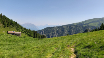
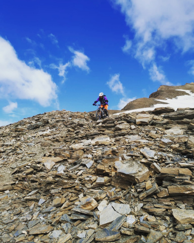
Going left along the dirt road in a short time you reach the Elena Tironi refuge, elevation 1700 meters. Here begins a beautiful path that you partly pedal, partly push and partly carry. At Malga Rosellino you take a path to the left, reaching, after a beautiful waterfall, the Marino bassi bivouac. You push a little further, until you reach the niche of San Glisente, elevation 1980 meters. Biking on your back, you have to climb the steep ridge of Mt. Fra. Passing just below the summit, you continue biking on a nice path to a large cairn of stones. you descend a few meters and continue climbing up the colma Di San Glisente, elevation 2160 meters.
Admiring the view and changing the set-up, the descent begins.
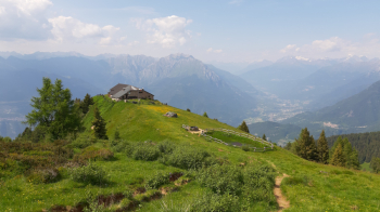
The first section runs on splendid and scenic ridge, without great difficulty until the hermitage of San Glisente. The ancient hermitage, located on a pulpit overlooking the lower Camonica Valley, at an altitude of 1940 meters, is definitely worth a stop.
Now following the trail kindly provided to me by a local, one resumes the descent, taking (SW direction) the steep access to the path leading to the nearby Ca' del Pastore. From the hut you spot, at some signposts (do not follow for Malga Foppole) the path (W direction) that with an exposed but very nice stretch leads to a fountain in the meadow (Località Grasso Lungo). Here turn right, descending along the grassy ridge (off-road signs). Crossing a dirt road we turn left then immediately down right following a cut through the woods. In the clearings below continue down, cross the forest (wild section) to a meadow (pasture) skirted left until you reach malga Pianazzo (respect the pasture and any electrified fences). WARNING: here it is not convenient to follow the gps track but to follow the road to the right until the Budec bivouac and from there to take a trail (back on the track) definitely technical, challenging, with some super stomach-churning but really satisfying drops. The trail ends on a small road near Dosso di Selz. Past the houses of Guillo, turn left at a fork, steeply downhill to an old house in a meadow (it is private property, be careful). Keeping to the right in the meadow, halfway down, locate a path whose start is partially barricaded by branches and logs across. The last path begins, a tiny bit dirty but very nice, ending practically at the bottom of the valley near the hamlet of Plemo in the municipality of Esine.
Turning first to the right and then to the left, we enter a tunnel that passes under the Valle Camonica highway, leading onto the beautiful Oglio Sud bicycle and pedestrian path. Pleasantly skirting the river, you return to Montecchio, the starting point.