Italiano
 Deutsch
Monte Pizza San Gervasio/Protasio

Monte Pizza in Bagossa land. The name would seem to give it an unboldly festive nature thus betraying its true nature. If Pizza has to be it is certainly very spicy, an Inferno I would call it.
We start in Bagolino from the Di Romanterra bridge (park just before the bridge entrance on the state highway) and go up the Berga road and after 1.5 km and 150 meters of elevation gain we find signs directing us to the little Church and Hermitage of San Gervasio and Protasio, a must do for the mystical atmosphere of the place, the exceptional view of Bagolino and the fun trail back (the same as the climb) where there is no shortage of peppery segments, I have descended more than once. We pick up the Berga road right where we had left it and follow it up to an elevation of 980 meters to leave it by turning right onto a dirt forestry road marked "Palestra di roccia."
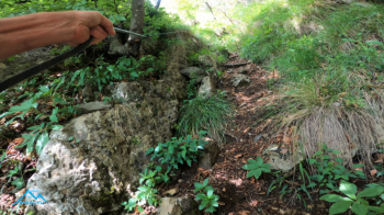
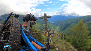
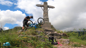
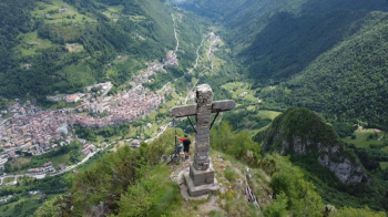
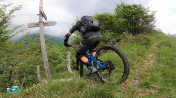
We walk along the beautiful forest road with never exaggerated gradients until we reach an altitude of about 1180. The cakewalk ends here, the next 250 meters or so of elevation gain between us and the summit are very, very challenging, the bike that won't come off the shoulders again. The path has become feeble and very steep with vegetation that forces us to continually struggle to disentangle the ends of the bike from the foliage then, a segment equipped with fixed ropes that reassure us and help in no small part, and when these end the summit we can feel it is now close. We are on the ridge that already reveals the path for the return to the left and to the right the short traverse that will lead us to the summit, so I thought, in fact the huge and majestic cross is placed on the anticima of Monte Pizza, the forested summit is a short distance away.
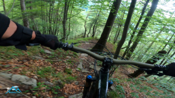
Super, super spectacle, never seen Bagolino like this in all its splendor, from the Pian d'Oneda (Lake Idro) to the Cornone del Blumone without the gaze being interrupted in the slightest, unique balcony in this fragment of the world. It is time to descend, the entrance is well marked and we set off hopeful but with the knowledge that the summit of Monte Pizza is a pyramid and if the ascent was very steep the descent will be no less. In fact the first slope is not done in the saddle, there is none for anyone.
Reading the topography the ascent trail the one to the south was assigned the grade of T3 while the descent T5, in truth I did not appreciate differences so I downgrade T5 to T3.
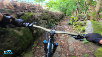
Regardless, the first 200 meters of elevation gain can be done only with bikes on the side and with great care, (I then rode it wet) then, past the vertical segment the fun is at full throttle passing by the pretty village Pissidolo and down to the Selva bridge, and again with a short junction on the state highway to the Di Romanterra bridge, pure joy.
This trip is modest when understood in terms of elevation gain and Km but absolutely not to be underestimated technical difficulty relatively the 250 meters of the summit in both directions.