Italiano
 Deutsch
Monte Caucaso passo Croci San Rocco

Very rewarding itinerary with a long but beautiful climb and an amazing descent very scenic and a bit adventurous. Starting from Ferrada we take Via dei Barbieri and begin the long climb (22km) that will take us to the top of Mount Caucasus at an altitude of 1250 meters. Shortly after Moconesi the road becomes unpaved and stays that way until it joins the Provinciale del Passo della Scoglina. The climb remains steady and beautiful. Arriving at Piani di Struvega we could leave the dirt road for a push section heading to the summit but today we decide on a totally pedaled ride.
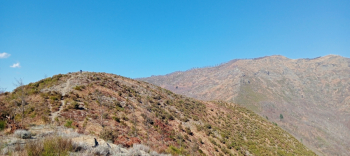
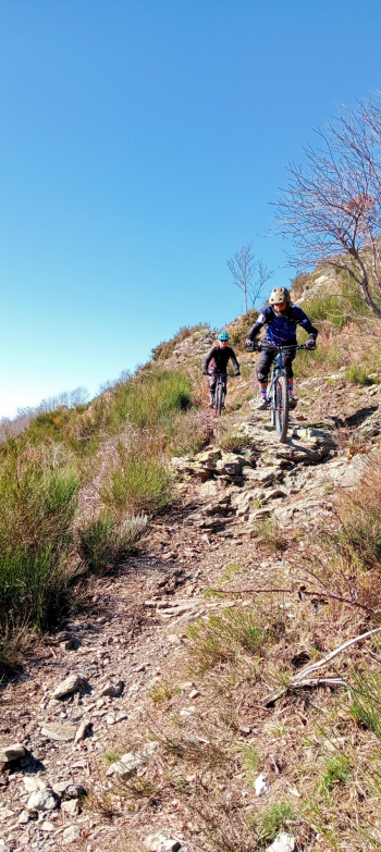
As we progress the roadway narrows to a nice single track and begins to descend, with a few technical passages. When we reach the Scoglina Pass we follow the signs for Mt. Caucasus continuing the ascent on asphalt on a beautiful mountain road through a beautiful forest. Just before the Barbagelata refuge we turn right on a wide path and finally reach the summit of Caucasus with attached refuge. The view from the summit is amazing, too bad that today despite the beautiful day there is a slight haze.
Before tackling the descent we stop at the refuge for a drink and a piece of cake welcomed by Maurizio, its very helpful manager whom I had already contacted the previous days to find out about the condition of the trail. The descent is amazing always on the ridge on a rocky bottom and super panoramic. We transit from Croci Pass, Monte Rocio to the Chapel of San Rocco where the ridge ends. At this point we would have the opportunity to descend on the road made in the morning to retrace it to the Slate Benches in order to descend the descent called precisely Panchine, but for reasons of time we decide to postpone this descent until the next time we return.
So we continue on a path right in front of the Chapel that should lead us to Moconesi. The path becomes really difficult but doable too bad that it soon becomes very closed by vegetation making us choose a seemingly more open and equally technical alternative. Arriving very close to the houses the situation worsens forcing us to improvise here and there on cleaner tracks.
PS: For those who should undertake this tour I recommend the alternative desccritta arrived at the chapel of San Rocco unless you are adventurous and equipped with excellent skills.