HOME RANKINGS CHALLENGES ROUTES POI PLANNING SEARCH LOGIN
Italy - Trentino-Alto Adige/Südtirol, BZ
2023/03/07 22:16:05

Rifugio Payer con discesa 19a

5 Downloads
1
 
Author
nonnocarb
(266)
Place
Italy - Trentino-Alto Adige/Südtirol, BZ
Km
23,08 km
Elapsed time
06:35:59
Vertical meters
+1 700 mt (1271 - 3034)
Route difficulty
Landscapes
Last update
2023/03/09 09:37:11
Comments
0
Description

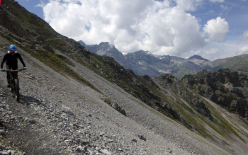
Itinerary with fantastic views, right below the Ortles, and very fun trails. At the same time, however, reserved for experts because of the great difficulty and exposed trails, where you have to be very careful and to the many uphill portage sections.

From Gomagoi you go up on asphalt to Solda. Before reaching the village go up right on the very steep forsetale, then on the trail to the Tabaretta hut, the first part pedaled then pushing. After the hut push and shoulder to the Bear Pass.

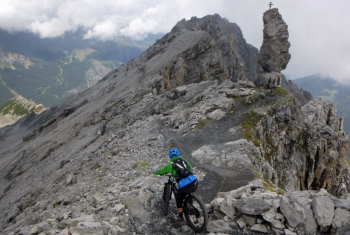
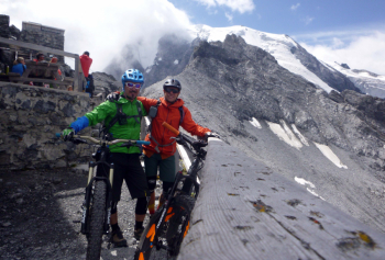
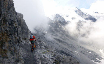
From here stretch not long but very exposed with safety wire cable, spectacular, to fork for descent. Ascent to Payer with bike on shoulder and rest in hut with excellent strudel. From here breathtaking descent with superb views on trail 19 to Trafoi, from the fork at elevation 2900 almost all bikeable. Beware of the junction to follow to trail 19a, this trail is quite complicated due to numerous landslides, with bikes to be carried by hand, and some very steep and technical sections. On the other hand, you get to the car all on trail.

Be careful, many hikers from Solda go up to the Payer. Better to go up very early to avoid being in traffic with your bike on your back on the narrow trail. On the 19a trail, on the other hand, almost no one.

The most fun trail down to the valley, however, remains trail 19 to Trafoi

Download our free mobile app to send this route to your Garmin device or to navigate it on OSM maps. Android - iOS

Graph

Nearest Routes

2023/03/05
- Italy - Trentino-Alto Adige/Südtirol, BZ
nonnocarb
(266)
37,16 km
Km
+1 730 mt
Vertical meters
Route difficulty
Landscapes
2024/02/02
- Italy - Trentino-Alto Adige/Südtirol, BZ
nonnocarb
(266)
16,43 km
Km
+1 000 mt
Vertical meters
Route difficulty
Landscapes
2023/10/01
- Italy - Trentino-Alto Adige/Südtirol, BZ
Robibz
(19)
27,94 km
Km
+1 313 mt
Vertical meters
Route difficulty
Landscapes
2022/11/04
- Italy - Trentino-Alto Adige/Südtirol, BZ
nonnocarb
(266)
31,74 km
Km
+1 832 mt
Vertical meters
Route difficulty
Landscapes
2024/02/02
- Italy - Trentino-Alto Adige/Südtirol, BZ
nonnocarb
(266)
12,89 km
Km
+450 mt
Vertical meters
Route difficulty
Landscapes
2023/09/14
- Italy - Trentino-Alto Adige/Südtirol, BZ
makihl
(3)
51,99 km
Km
+2 400 mt
Vertical meters
Route difficulty
Landscapes
2023/03/02
- Italy - Trentino-Alto Adige/Südtirol, BZ
nonnocarb
(266)
40,98 km
Km
+1 980 mt
Vertical meters
Route difficulty
Landscapes
2023/03/04
- Italy - Trentino-Alto Adige/Südtirol, BZ
nonnocarb
(266)
84,83 km
Km
+2 050 mt
Vertical meters
Route difficulty
Landscapes
2024/01/02
- Italy - Trentino-Alto Adige/Südtirol, BZ
@ff.mtb
(9)
44,55 km
Km
+1 700 mt
Vertical meters
Route difficulty
Landscapes
2022/09/01
- Italy - Trentino-Alto Adige/Südtirol, BZ
steve-U
(21)
37,74 km
Km
+2 018 mt
Vertical meters
Route difficulty
Landscapes

0 Comments