Italiano
 Deutsch
Monte Moneglia e Punta Baffe

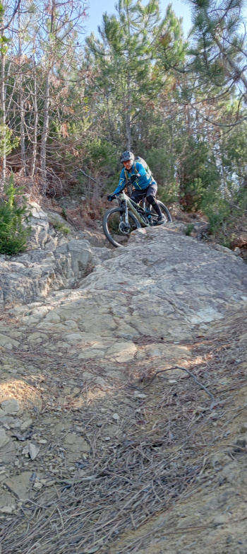
Having parked the car in a large parking lot near the highway exit, we mount the saddle and ride along the Aurelia in the direction of the Bracco Pass. After about 3.4 km we turn right onto a beautiful dirt road that runs at the foot of Mount Moneglia and leads to Colle del Lago.We follow the signs for Moneglia on Cai 412/420 a beautiful traverse that bypasses both Mount Moneglia and Mount Comunaglia. The trail is nothing short of stunning, perhaps the most beautiful of any I have done on the Ligurian coast. It climbs in the first part with a few non-bikeable spots, and then drops off just before intersecting the path down from Comunaglia where it becomes ultrapanoramic. It is never too challenging, but there is no shortage of technical sections where we can try our hand at it and take some photos.
After about 10.6 km near the junction for Moneglia we turn right onto Cai 415 uphill until we catch up with the asphalt road that leads us back onto the Aurelia in the locality of Ca' Bianca. We descend in the direction of Sestri and at km 14.3 we take Cai 415, a nice single track that turns into a road and takes us to Casarza Ligure, totally losing altitude.
We resume the ascent passing through Navano to come out du again on the Aurelia right at the point where the path that joins Cai 414 leads on Moneglia attacks.
The path is really steep forcing us to do a bit of shoulder biking followed by a push section, definitely pedalabike if equipped with an ebike. When we arrive near a small rest area we can get back in the saddle practically all the way to the summit of Moneglia.
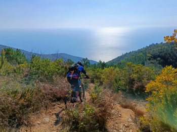
Just before the latter, however, we turn right onto Cai 413 on a technical descent that leads to Colle del Lago from where we had already passed. Continuing Cai 413 we reach Punta Baffe we pass by the tower of the same name and continue the descent (U-Turiun) to Riva Trigoso.This trail is also very nice, technically fast and very enjoyable. For those who want to shorten the tour you can avoid going to Punta Baffe and descend on the Manierta a trail on the inner ridge a little more technical than the U-Turiun but perhaps less interesting from a landscape point of view.