HOME RANKINGS CHALLENGES ROUTES POI PLANNING SEARCH LOGIN
Italy - Valle d'Aosta, AO
2022/09/04 18:23:26

Col des Bornes from Chambave - with the Bikexplorers

7 Downloads
1
 
Author
gmzolenart
(104)
Place
Italy - Valle d'Aosta, AO
Km
32,99 km
Elapsed time
06:10:42
Vertical meters
+1 458 mt (498 - 1835)
Route difficulty
Landscapes
Last update
2022/10/05 21:05:14
Comments
0
Description

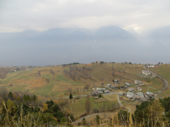
Fun tour in the Aosta Valley, in the Chambave area. Wonderful ascent, mostly on asphalt, through vineyards and green meadows, following signs to Verrayes, Champlong and Colle Saint Pantaleon.

Then dirt road with non-trivial tears until a magnificent traverse on trail 6 leading to Col des Bornes (1781 m).

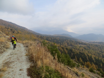
Another nice traverse, partly downhill on trail 2 toward belvedere Saint Pantaleon, from Commune de Verrayes to Commune de Torgnon, and then to Chapel de St. Evence. Here short technical section with steps and narrow hairpin bends. Then Lavese forest road and sr 12.

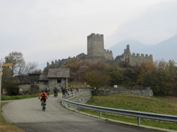
The descent continues on trail 1, worth the digression to the Castle of Cly, one of the primitive type of Valdostan castles with wide walls built in the 11th century by the Cly branch of the Challants and then passed to the Savoy, it included the parishes of Verrayes, Chambave and the entire Valtournenche.

Finally, by trail 4 return to Chambave (568 m).

Medium-mountain route, good for all seasons.

The Hiker Publisher No. 13 Central Valley - Trail Map (1:25,000)


Download our free mobile app to send this route to your Garmin device or to navigate it on OSM maps. Android - iOS

Graph

Nearest Routes

45,84 km
Km
+2 206 mt
Vertical meters
Route difficulty
Landscapes
2022/10/25
- Italy - Valle d'Aosta, AO
paiogs
(12)
28,41 km
Km
+2 400 mt
Vertical meters
Route difficulty
Landscapes
2023/03/10
- Italy - Valle d'Aosta, AO
gmzolenart
(104)
28,72 km
Km
+1 121 mt
Vertical meters
Route difficulty
Landscapes
2023/11/27
- Italy - Valle d'Aosta, AO
33,54 km
Km
+1 450 mt
Vertical meters
Route difficulty
Landscapes
2022/10/11
- Italy - Valle d'Aosta, AO
gmzolenart
(104)
25,12 km
Km
+1 122 mt
Vertical meters
Route difficulty
Landscapes
2022/08/05
- Italy - Valle d'Aosta, AO
gmzolenart
(104)
20,20 km
Km
+989 mt
Vertical meters
Route difficulty
Landscapes
2023/01/10
- Italy - Valle d'Aosta, AO
orso91
(1)
15,98 km
Km
+625 mt
Vertical meters
Route difficulty
Landscapes
2022/09/02
- Italy - Valle d'Aosta, AO
paiogs
(12)
47,61 km
Km
+2 400 mt
Vertical meters
Route difficulty
Landscapes
2023/02/05
- Italy - Valle d'Aosta, AO
BAROLO71
(33)
27,80 km
Km
+2 099 mt
Vertical meters
Route difficulty
Landscapes
2022/08/22
- Italy - Valle d'Aosta, AO
nonnocarb
(266)
30,60 km
Km
+1 265 mt
Vertical meters
Route difficulty
Landscapes

0 Comments