Italiano
 Deutsch
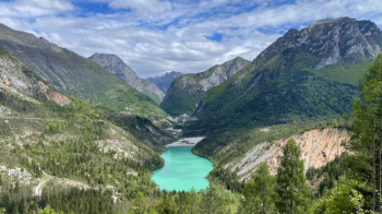
Diga del Vajont - Erto - Casso

Cyclo-mountaineering route starting in Longarone, ascent on asphalt to beyond the dam and detour to the road on the right crossing the landslide to turn near San Martino, continuation on asphalt to Erto, ascent to Casera Mela to take the Troi del Scjarbon, on the coast pushing and pedaling over a number of small landslides to Casso, continuation on Troi di Sant Antoni, technical in the second half, to Longarone.
Start at Longarone park fairgrounds, cross Piave River and climb up through Codissago taking first right to old quarry, from which a dirt road leads to new memory ferrata park, take main asphalt and climb up past Vajont dam. At the next junction, go up the Monte Toc landslide and follow the scenic road past the reservoir until you reach the road to Erto. Ride a few more meters of asphalt and descend to the left along the bike path with a couple of violent downhill and uphill ramps to reach Erto Vecchia, from which you climb to Erto Nuova and continue in the direction of Casera Mela.
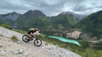
At the left hairpin bend that enters the valley you leave the asphalt for the coast path, the Troi del Scjarbon, which is narrow and partly landslide, perhaps disused. Partially cyclable it leads to a junction with a well-trodden path that climbs in exposed sections first into the woods and then up and down on rock, very scenic with splendid views of the reservoir, with several crossings over landslides and scree. Long and pleasant, almost all of it cyclable, it leads to Casso, beyond which, at the cemetery, you take the Troi di Sant Antoni, with bottom on grass, then forest and increasingly rocky until a hairpin bend on the descent to Longarone. Continue on path next to the road with a more technical and challenging bottom, rocky and with steps. In a short time you reach the village in the valley.
Asphalt 50% - Trails 40% - Dirt 10%; Physical condition: medium challenging; Technical difficulty: challenging;