
 Italiano
 Deutsch
2022/10/26 00:13:47
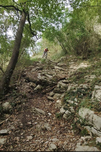
Sentiero 113 (Corna delle capre)
Author

Place
Italy - Lombardia, BG
Km
2,23 km
Elapsed time
00:10:50
Vertical meters
+17 mt (746 - 868)
Route difficulty
Landscapes
Last update
2023/09/17 17:16:41
Comments
Hotels
Description
It is reached by climbing sa Serina or descending from Canto Alto.
The trail is very technical, exposed in places and often forces you to descend and do from sections with the bike in hand, there in the middle of the trail there are quite a few s3/4 passages also quite exposed (put a lot of attention), after passing the little river a last technical section and then improves a lot reconnecting to the Cambli fork.

Local weather
Thu 00:00

19 °C
Thu 12:00

24 °C
Fri 00:00

21 °C
Fri 12:00

25 °C
Sat 00:00
21 °C
Sat 12:00
25 °C

Graph
Nearest Routes
2,12 km
Km
+250 mt
Vertical meters
Route difficulty
Landscapes
2,26 km
Km
+20 mt
Vertical meters
Route difficulty
Landscapes
2,21 km
Km
+10 mt
Vertical meters
Route difficulty
Landscapes
2,83 km
Km
+48 mt
Vertical meters
Route difficulty
Landscapes
26,50 km
Km
+1 450 mt
Vertical meters
Route difficulty
Landscapes
24,38 km
Km
+1 300 mt
Vertical meters
Route difficulty
Landscapes
37,16 km
Km
+1 850 mt
Vertical meters
Route difficulty
Landscapes
39,16 km
Km
+1 462 mt
Vertical meters
Route difficulty
Landscapes
23,89 km
Km
+1 250 mt
Vertical meters
Route difficulty
Landscapes
39,34 km
Km
+1 614 mt
Vertical meters
Route difficulty
Landscapes