
 Italiano
 Deutsch
2026/03/13 17:34:52
Bassano Trail Area Short Route
Author

Place
Italy - Veneto, VI
Km
26,74 km
Elapsed time
02:32:46
Vertical meters
+650 mt (113 - 459)
Route difficulty
Landscapes
Last update
2026/04/08 09:58:59
Comments
Hotels
Description
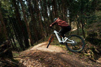
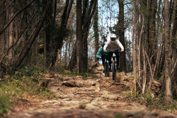
A route that includes the three trails closest to and most easily accessible from the center of Bassano.
The climb takes place on paved and forest roads, including a section of the Altavia del Tabacco, before descending into Valsugana along the Canada Trail. The second trail on the route is the iconic Europeo, a historic trail that hosted the European Downhill Championships in the late 1990s and the most technical section of the itinerary. The ride concludes with the short and fun Gin Tonic, a flow trail perfect for heading back to Bassano.
Local weather
Thu 00:00

23 °C
Thu 12:00

30 °C
Fri 00:00

27 °C
Fri 12:00
32 °C
Sat 00:00
28 °C
Sat 12:00
30 °C


Graph
Nearest Routes
51,55 km
Km
+2 010 mt
Vertical meters
Route difficulty
Landscapes
54,51 km
Km
+2 050 mt
Vertical meters
Route difficulty
Landscapes
36,99 km
Km
+1 350 mt
Vertical meters
Route difficulty
Landscapes
18,72 km
Km
+900 mt
Vertical meters
Route difficulty
Landscapes
32,83 km
Km
+1 050 mt
Vertical meters
Route difficulty
Landscapes
21,53 km
Km
+1 150 mt
Vertical meters
Route difficulty
Landscapes
16,93 km
Km
+1 000 mt
Vertical meters
Route difficulty
Landscapes
29,05 km
Km
+1 630 mt
Vertical meters
Route difficulty
Landscapes
67,58 km
Km
+1 850 mt
Vertical meters
Route difficulty
Landscapes
25,59 km
Km
+1 300 mt
Vertical meters
Route difficulty
Landscapes