HOME RANKINGS CHALLENGES ROUTES NEAR ME PLANNING SEARCH LOGIN
Italy - Emilia-Romagna, MO
2025/10/14 18:03:59

Colle dell'Acquamarcia e sentiero dei Giganti

4 Downloads
0
 
Share

Key Takeaways / Scheda Tecnica

Disciplina:
Mountain Bike (MTB)
Percorso:
Colle dell'Acquamarcia e sentiero dei Giganti
Località:
Italy - Emilia-Romagna, MO
Distanza:
30,18 km
Dislivello Positivo:
+1 496 mt (Quota Min: 518m - Max: 1728m)
Difficoltà Tecnica:
3/5
Valutazione Panorami:
4/5
Formato Traccia:
GPX Download disponibile
Author
ebsat
(129)
Place
Italy - Emilia-Romagna, MO
Km
30,18 km
Elapsed time
05:50:04
Vertical meters
+1 496 mt (518 - 1728)
Route difficulty
Landscapes
Last update
2025/10/14 22:20:27
Comments
1
Description

Beautiful MTB tour among breathtaking views, exciting descents and technical trails: a complete route that gives emotions from the first to the last ride. Departure from Lido di Fanano, from where we start climbing on asphalt road until we reach Capanno Tassoni, where we take a well-deserved break. We then resume the climb along the beautiful forest road that takes us up to Passo della Croce Arcana. From here we take the spectacular ridge route to reach Cima dei Balzoni, the highest point of the entire tour. Except for the last stretch, where you need to push or carry your bike on your back, the climb is practically all bikeable.

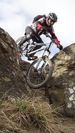
From the top begins the most adrenaline-pumping part of the tour: the descent to Ospitale, combining CAI 417 and CAI 419 trails. The first section is very challenging, with passages on rocks, sections with roots and a rather steep final section (difficulty S3). Reaching the roadway coming from Capanno Tassoni, we continue on 417, which softens slightly in the second part (difficulty S2). Arriving in Ospitale, we stop briefly in the square to fill our water bottles.

We then set off again, descending for a few hundred meters to take the Trail of the Giants, so named because of the majestic chestnut trees that line it.

The trail is well-maintained and winds between continuous ups and downs, with some rather steep ramps and very fast downhill sections. We end this fantastic loop on CAI 411, which gives us a final, albeit short, technical and fun segment-the worthy finale to a tour that is complete in every way.

Download our free mobile app to send this route to your Garmin device or to navigate it on OSM maps. Android - iOS
Local weather
Mar 00:00
11 °C
Mar 12:00
19 °C
Mer 00:00
17 °C
Mer 12:00
19 °C
Gio 00:00
15 °C
Gio 12:00
15 °C
Ven 00:00
6 °C
Ven 12:00
15 °C
Sab 00:00
11 °C
Sab 12:00
10 °C

Graph

Nearest Routes

2023/09/30
- Italy - Emilia-Romagna, BO
Paoloc1
(135)
43,80 km
Km
+2 200 mt
Vertical meters
Route difficulty
Landscapes
2023/05/24
- Italy - Emilia-Romagna, MO
bonfi62
(11)
29,54 km
Km
+1 370 mt
Vertical meters
Route difficulty
Landscapes
2023/08/28
- Italy - Emilia-Romagna, MO
ebsat
(129)
35,15 km
Km
+1 612 mt
Vertical meters
Route difficulty
Landscapes
2023/06/21
- Italy - Emilia-Romagna, MO
ebsat
(129)
34,28 km
Km
+1 460 mt
Vertical meters
Route difficulty
Landscapes
31,85 km
Km
+1 457 mt
Vertical meters
Route difficulty
Landscapes
2025/06/02
- Italy - Emilia-Romagna, MO
Paoloc1
(135)
36,25 km
Km
+1 600 mt
Vertical meters
Route difficulty
Landscapes
2023/03/06
- Italy - Toscana, PT
giobike73
(49)
36,98 km
Km
+1 727 mt
Vertical meters
Route difficulty
Landscapes
2023/03/01
- Italy - Emilia-Romagna, MO
nonnocarb
(324)
33,06 km
Km
+1 500 mt
Vertical meters
Route difficulty
Landscapes
2025/10/11
- Italy - Emilia-Romagna, MO
Paoloc1
(135)
32,67 km
Km
+1 700 mt
Vertical meters
Route difficulty
Landscapes
2023/03/04
- Italy - Toscana, PT
giobike73
(49)
37,20 km
Km
+1 860 mt
Vertical meters
Route difficulty
Landscapes

1 Comments