
 Italiano
 Deutsch
Passo Zebrù extra large

_ tour conducted on July 18, 2025_
Loop tour from Bormio, touching all the huts in Val Cedec and Val Zebrù (except the Casati hut, off-loop and anyway closed for renovation at this time), and crossing Zebrù Pass at 3,005 meters. Splendid but challenging itinerary, with 1 hour of backpacking, at least 45 minutes total by push bike, and 1 passage with chains on descent.
Starting in Bormio (1,200 meters), at the bridge over the Adda River take the easy bike path to San Antonio, following the course of the Frodolfo River. At San Antonio, unfortunately, the bike path ends and you continue on the state road to Santa Caterina (1,750 meters). Here you take the Via Forni (paved, car toll access) that leads up to the 2,220-meter Rifugio Ghiacciaio ai Forni.
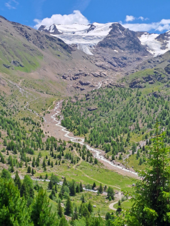
From Rifugio Forni take the trail to Rifugio Branca (2,450 meters), which is wide but in places uneven and with some major ramps. However practically all rideable with a bike if you are well trained. The alternative (not tried) is the jeeppable parallel to the trail, which passes higher up (on sight, however, even this still has challenging ramps). On the way up, splendid panorama with the Frodolfo stream, the Forni glacier and at the bottom the Punta San Matteo at 3,678 meters.
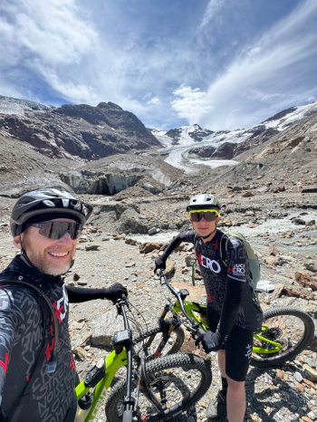
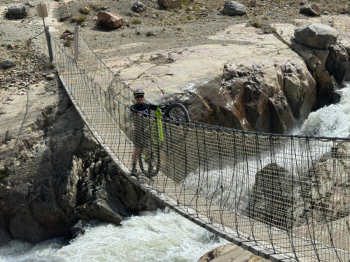
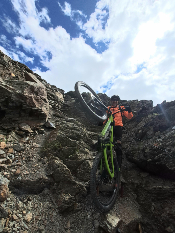
From the Branca hut you descend 50 meters again and near the small lake you take the High Glaciological Trail (be careful not to make a mistake at the crossroads, it is the central trail), which, after a section that is a bit pedalable and a bit not, and a 50-meter passage with a backpacking bike, arrives at the 2,500-meter Tibetan bridges.
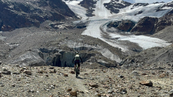
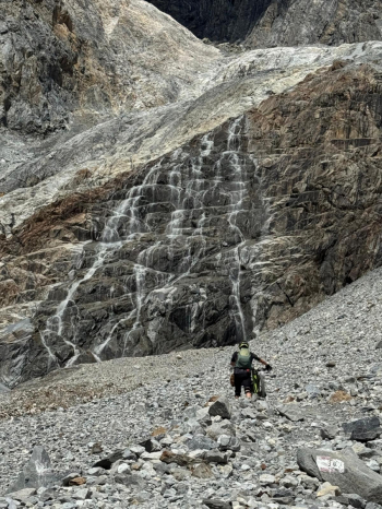
From the first Tibetan bridge you can pedal left up the moraine for a 100-meter difference in elevation, arriving right at the base of the Forni Glacier (2,620 meters, nice scenery, worth it, but sad when compared to memories of what the glacier looked like 40 years ago, and where it reached compared to today).
From here you retrace your steps, regain the first Tibetan bridge and then to follow the second one as well. Here another short push section. Then the descent begins: first 6-7 minute non-cyclable section (large steps of fixed rocks smoothed by the retreating glacier), then shortly afterwards you meet the junction between High and Low Glaciological Trail: the Low (to the right at the junction) is all cyclable (too much so! It was flattened recently to make it more accessible, but to whom?) and quickly gains the valley floor and then the Forni Hut again.
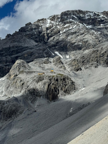
Obligatory stop for refreshment (but without exaggerating that there is still a lot of climbing ahead), then take the jeeppable to Rifugio Pizzini: immediately 2 leg-cutting hairpin bends, then it's all quieter. Occasionally a few jeeps pass by with the bikes of those who don't want to pedal that stretch in their carts (these alpine environments should be sweated to the bottom - personal opinion). Wonderful views from the top of the Forni valley just crossed.
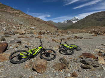
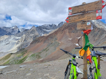
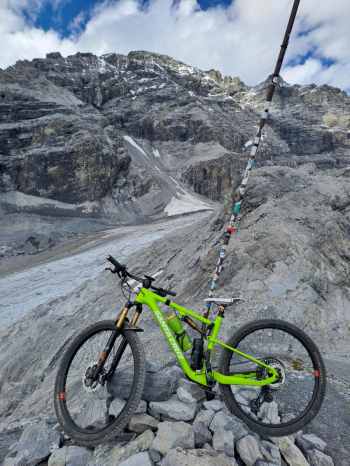
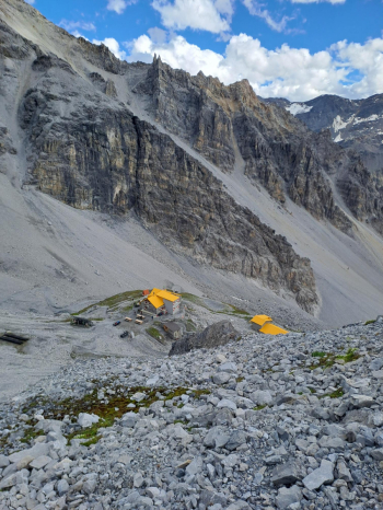
From Rif. Pizzini (2,700 meters), beautiful views toward Rifugio Casati, Gran Zebrù and Cevedale, take (10 meters below the refuge) the path leading to Passo Zebrù: 300 meters of pushing bike with a few dozen meters pedaled every now and then. At the pass (3,005 meters) spectacular views everywhere you look!
From here you descend for 300 meters, alternating between bikeable sections, challenging but doable sections in the saddle, a section with chains, a couple of snowfields, a few short exposed sections. Very little flow but very varied and rewarding.
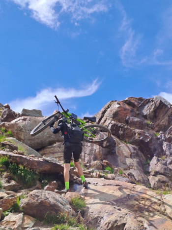
At 2,700 meters at the junction we take a right, climbing up and then down for a stretch to 2,550 meters, then 1 hour of backpacking biking to the V° Alpini hut awaits us (initially a couple of challenging passages, then in the second section a nice traverse on scree).
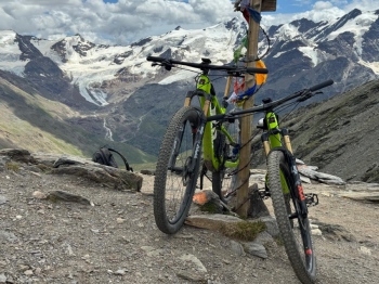
Up to 2,750 meters, to cross the jeeppable that goes up to the refuge. The last 100 meters unfortunately prove equally un-pedalable: the jeeppabile is a scree and boulders scree with very challenging gradients, you struggle and even slip to push up the bike by hand! Gritting your teeth, you reach the 2,850 meters of the V° Alpini Refuge. And with a little last effort it is worth climbing another 50 meters beyond the hut to enjoy the beautiful view of the Zebrù Glacier, as well as the trail you have just traveled.
From the Refuge V° Alpini, descent to the 2,150 meters of the Baita del Pastore: the first 200 - 250 meters of jeeppable are equally well difficult to do in the saddle even downhill (always due to gravel, scree and gradients), then it becomes nice and fun until the Baita. From here continue downhill on fast and fun jeeppable, passing by Rifugio Campo and then at the turn of Niblogo (be careful, in the heat of the descent at the fork at an altitude of 1,650 meters do not keep left for Pradaccio but take right).
At Niblogo (1,600 meters) return to civilization and asphalt, but only up to the 1st hairpin bend on the descent: here you can go straight ahead taking the up-and-down Canareglia road and then abandon it by following local trail signs that pass through the woods, clean and very flowing trails (average difficulty S1, just enough to have fun at the end of such a strenuous ride), and that finally lead down right into downtown Bormio.
