HOME RANKINGS CHALLENGES ROUTES NEAR ME PLANNING SEARCH LOGIN
Italy - Friuli-Venezia Giulia, UD
2025/08/25 14:07:18

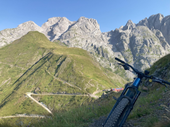
Pic Chiadin - Monte Floriz - Givigliana

0 Downloads
0
 
Share
Author
MarcoSer
(3)
Place
Italy - Friuli-Venezia Giulia, UD
Km
27,70 km
Elapsed time
24:37:33
Vertical meters
+1 850 mt (694 - 2256)
Route difficulty
Landscapes
Last update
2025/08/25 21:55:35
Comments
0
Description

A lengthened version of Civi65's ride, whose link I provide.

Here you start from Rigolato going down the state road to the left fork for the hamlets Tors and Givigliana. You leave the asphalt after the third hairpin bend and continue on a dirt road to Collinetta, where you join the road to Tolazzi and then to Marinelli. The climb ends at Pic Chiadin, pushing for 20 minutes even with eMTB. The views make up for the effort, but the trail back to Marinelli is not particularly fun (I suggest climbing from the switchbacks that remain on the left side, but descending directly from the trail in the meadow below the summit-more cyclable and less exposed).

From Marinelli you climb up and down the ridge that leads below Crostis, passing Mount Floriz (5 minute push) and arriving at Plumbs Fork. The whole route is easy, but exposed, with a few switchbacks that require nose press. From the fork we drop right down to casera Plumbs cutting across the pastures on an easy S1 trail. Past the casera and a couple of switchbacks on a dirt road, take a hidden fork with signs for Givigliana and Biocje saddle. The trail is poorly traveled and difficult to follow without a GPS track. It is only 60 meters of elevation gain, but you struggle to push and carry your bike (also possible to go around Mt. Bioichia by following the dirt road and turning left at each fork).

From Sella Biocje you descend on a steep but never difficult trail to Givigliana and, after crossing the village, continue on single track to the Sglinghin bridge over the Degano.

A short ascent brings us back to the Rigolato parking lot.


Download our free mobile app to send this route to your Garmin device or to navigate it on OSM maps. Android - iOS
Local weather
°C
°C
°C
°C
°C
°C
°C
°C
°C
°C

Graph

Nearest Routes

2022/09/27
- Italy - Friuli-Venezia Giulia, UD
civi65
(106)
30,18 km
Km
+1 628 mt
Vertical meters
Route difficulty
Landscapes
2023/03/09
- Italy - Friuli-Venezia Giulia, UD
civi65
(106)
15,42 km
Km
+1 100 mt
Vertical meters
Route difficulty
Landscapes
2023/03/09
- Italy - Friuli-Venezia Giulia, UD
civi65
(106)
22,93 km
Km
+1 070 mt
Vertical meters
Route difficulty
Landscapes
2024/08/29
- Italy - Friuli-Venezia Giulia, UD
MarcoSer
(3)
10,79 km
Km
+850 mt
Vertical meters
Route difficulty
Landscapes
2022/10/02
- Italy - Friuli-Venezia Giulia
31,66 km
Km
+1 577 mt
Vertical meters
Route difficulty
Landscapes
2023/03/07
- Italy - Friuli-Venezia Giulia, UD
civi65
(106)
21,78 km
Km
+1 470 mt
Vertical meters
Route difficulty
Landscapes
2022/10/13
- Italy - Friuli-Venezia Giulia, UD
civi65
(106)
21,11 km
Km
+1 394 mt
Vertical meters
Route difficulty
Landscapes
38,42 km
Km
+1 440 mt
Vertical meters
Route difficulty
Landscapes
2023/03/02
- Italy - Friuli-Venezia Giulia, UD
civi65
(106)
32,65 km
Km
+1 560 mt
Vertical meters
Route difficulty
Landscapes
2023/06/25
- Italy - Friuli-Venezia Giulia, UD
GiGaX73
(76)
18,99 km
Km
+1 190 mt
Vertical meters
Route difficulty
Landscapes

0 Comments