
 Italiano
 Deutsch
Sella Ronda senza impianti per Ebike

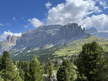
Sellaronda clockwise without lifts. This year I chose a more "flow" version than this one to arrive with a little more margin of energy in the batteries, and I excluded the DH of Ciampinoi (which requires a climb of ca 400 meters of elevation gain to do it). Route done with e-bike and 800Wh battery and at the end I arrived with 20% residual energy. The route follows the route of the classic SellaRonda (clockwise), but some variations were added in the descents (favoring more technical trails and of course the climbs on dirt or bike paths, avoiding asphalt which overall will be less than 3%). The route is very varied and well organized and there are always new features, such as the beautiful descent from Bec de Roces to Arabba.
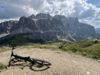
It starts from Arabba the ascent on a forest road that runs along the stream and arrives at the Pordoi Pass (nice steep final section). From the pass take the cai 601 that climbs gradually and leads to the Belvedere refuge and then descends to take the start of the Double U and then Infinity pistino towards Pecol; a smooth track with a few jumps, parabolics and steep sections in the final part. Before reaching Pecol, take a right to join Infinity and then AnimalHouse (which avoids a downhill section on the slope). This section has a few climbs, but then final descent is technical with passages over rocks, roots, steps and steeps (final part of the Rabber Trail) to Rifugio Lupo Bianco. Here you take the forest trail that climbs hard (especially the first section) to the Valentini Shelter to drop down to the Sella Pass shelter. Here you follow the dedicated bike trail that climbs up to Piz Seteur (original Sellaronda trail) and then descend the little pistino (Easy jump) which is a real blast, with steep steeps, parabolic compressions, jumps and spectacular wall rides.
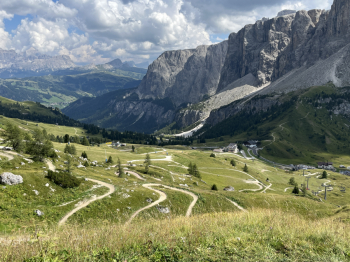
We proceed past the village and take the trail and then dirt road down to Selva di Val Gardena; unfortunately, this section is along the slope and is definitely the worst section of the entire tour (certainly not a good image for Selva di Val Gardena). The decidedly better, but more expensive alternative is to take the forest track that goes up to Ciampinoi, a long climb, medium gradient and excellent rideability (but ca 400 meters of elevation gain) and then, having climbed the Ciampinoi mountain, take the splendid DH; this too is a nice track, technical and varied, more reminiscent of the DH in Canazei but even better maintained as a bottom; apart from the nice final steep section.
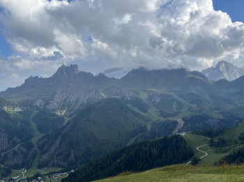
Back in Selva, by asphalt you climb to the start of the Dantercepis and follow the long dirt track also with medium gradient and excellent rideability, but very long. Arriving at the top station you take the little pistino that descends to Passo Gardena, very smooth and well shaped, with no technical difficulties. From the pass follow the little pistino (always on a flowing genre with curves, parabolics and bridges) that descends towards Corvara. After Colfosco trails and bike paths. From Corvara you take the asphalt climb to Arlara and then dirt track (always long but gradual, only a couple of tears in the final part) that reaches Rifugio Ciablun. Here you follow the ridge trail with its ups and downs to the Pralongià hut and then after a downhill section on trail you take the nice little pistino that goes down to the Incisa pass (smooth, parabolics, footbridges). From Incisa pass we take the little Fle pistino (very fun) that after a nice downhill section, climbs up to a forestry road that takes us to the trail that descends just below Campolongo Pass. One last hard climb to the Bec de Roches hut (technical in the second part) and the final little pistino that arrives in Arabba with a new series of switchbacks that avoid the old track trail (and Selva should learn from Arabba MTB).
=


