
 Italiano
 Deutsch
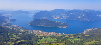
Punta Almana, balcone sul Lago d'Iseo
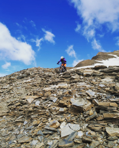
High-intensity ciloalpine (or cyclo-palpine, as I call it, since Punta Almana is part of the Brescian Pre-Alps) tour, challenging despite the relatively modest elevation gain because of the gradients, a long push/shoulder section, and the technical descent, S3 with a few passages of S4, with a short steep, bumpy, exposed section below the summit. Great views of Lake Iseo, nearby Mount Gugliemo, the Bergamo and Brescia Pre-Alps, and the Po Valley.
Departing from Gardone Val Trompia, m 316 (large parking lot in Via 2 Giugno, near the Carabinieri station), passing through the village we head up the asphalt road, practically to the top. Just before it ends at a house you turn left coming to a dirt widening. Opposite on the right, past a bar begins the steep cement road with ramps that sometimes exceed 30 percent, for a total of 500 meters of positive elevation gain. This ordeal ends (so to speak) at Passata at 960 meters.
Continue on the wide, steep trail 313 but only for about a hundred linear meters, then locating a narrower trail to the right that halfway up the steep forest, the first part is quite rideable, the middle part, uphill is push/shoulder and third and last part still becomes quite rideable. The trail ends on a smooth dirt road, passing by the beautiful Ronchi di Casere hut with views of Mt. Gugliemo. Continue first down a dirt road then a steep cemented ascent to Passo Spino, 1077 meters. Turn left to reach the nearby Forcella di Sale, 1108 meters.
Now turn left along a downhill dirt road passing by a fountain and a farmstead. Immediately after the farmstead you take a path that climbs right through a small, lush pine forest. The trail continues mostly pushing and then shouldering until you reach a ditch with a panoramic bench on the left, at elevation 1290, exactly one hundred meters below the summit. From here still with bike on the shoulder you climb the steep slope back up to the summit ridge reaching the large summit cross, 1390 meters, where there is a wonderful panorama.
The bike descent begins from the summit but to tackle the first steep, bumpy and for a stretch also a bit exposed you need good technique and good control of the bike, otherwise I recommend doing it on foot. When you reach the ditch again with a bench, turn right on a path halfway up in the grass (313 bis) to another fork with a signpost, where you continue straight on the ridge (path 237). First you push back up the ridge and then down a steep ridge and again down into the woods on a fun trail that ends at the small road where you passed earlier on the way up. Turning left you pass by the Ronchi di Casere malga, continue downhill on small road, at the first short ascent take a small road to the right that soon becomes a trail until you reach malga Casere, 933 meters. Now take the last long trail past the Purciola Pass, 877 meters, where the last challenging descent (S3 with a few steps of S4) leads to Val d'Inzino. Here it is worth a short detour up the valley to the rustic Rendena tavern for an ice-cold beer (and also for refreshment, should you need it).
