HOME RANKINGS CHALLENGES ROUTES NEAR ME PLANNING SEARCH LOGIN
Italy - Lombardia, BG
2022/10/15 14:45:03

Laghetti Ponteranica, Mincucco, Cantedolto

25 Downloads
2
 
Share
Author
ValeBG
(158)
Place
Italy - Lombardia, BG
Km
38,55 km
Elapsed time
03:11:09
Vertical meters
+2 050 mt (557 - 2105)
Route difficulty
Landscapes
Last update
2025/06/29 20:49:13
Comments
0
Description

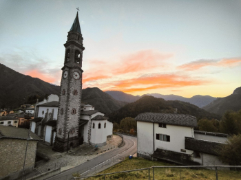
Spectacular tour with bike-mountaineering variant climb to Ponteranica ponds, descent from the famous Cantedolto The tour is within the reach of almost everyone, in fact in case you don't want to do the shoulder part you can avoid climbing to Ponteranica ponds. Start from Olmo al Brembo on a road that is never too steep we climb up to the plans of Avaro (water in the playground on the right). We continue on cemented road with very challenging slopes and deviate to the left with good pedal up to 1900 meters altitude (last 50 meters push due to too bumpy bottom).

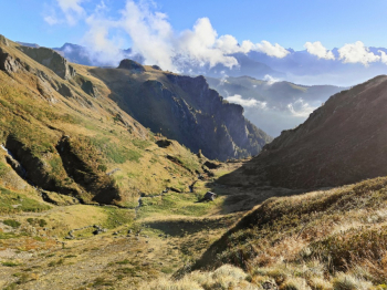
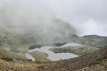
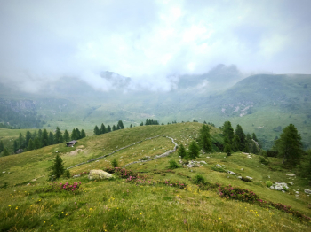
We push or shoulder bike and climb by trail to Ponteranica ponds. We descend by alpine trail S2. We continue to Mincucco with push sections and then descend from nice alpine trail S2 with last 50 metroi S3/4. We keep left and go up 200 meters on dirt road to San Marco pass. From here we continue to the Cantedolto refuge from which the famous spectacular medium S2 descent starts, alternating S1 with S2 sections and a couple of S3 passages. When you reach Averara (water) you take the classic fast and very nice descent to Olmo al Brembo with several relaunches and a few exposed points off trail.

Immagine che contiene aria aperta, cielo, nuvola, casa

Il contenuto generato dall'IA potrebbe non essere corretto. Immagine che contiene aria aperta, nuvola, natura, erba

Il contenuto generato dall'IA potrebbe non essere corretto.

Trail style: all mountain

Personal rating: views 9/10; descents 9/10

MTB: Yes

EMTB: Yes (if you're scared of pushing it, avoid the Ponteranica lakes)

Duration about 8h (by mtb)

Portage: 120/180m

Difficulty climb: A few challenging climbs but well rideable in general

Difficulty descent: S2/S3

Exposed: Some off-trail sections in the final traverse towards Olmo al Brembo

Draining: YES

Water points: Olmo al Brembo, Averara after the descent from Val Moresca

Download our free mobile app to send this route to your Garmin device or to navigate it on OSM maps. Android - iOS
Local weather
°C
°C
°C
°C
°C
°C
°C
°C
°C
°C

Graph

Nearest Routes

2025/06/22
- Italy - Lombardia, BG
ValeBG
(158)
37,23 km
Km
+1 850 mt
Vertical meters
Route difficulty
Landscapes
2022/10/16
- Italy - Lombardia, BG
ValeBG
(158)
26,51 km
Km
+1 200 mt
Vertical meters
Route difficulty
Landscapes
2023/10/29
- Italy - Lombardia, BG
ValeBG
(158)
29,79 km
Km
+1 500 mt
Vertical meters
Route difficulty
Landscapes
2022/08/24
- Italy - Lombardia, BG
ValeBG
(158)
52,37 km
Km
+2 400 mt
Vertical meters
Route difficulty
Landscapes
2022/10/15
- Italy - Lombardia, BG
ValeBG
(158)
30,92 km
Km
+1 900 mt
Vertical meters
Route difficulty
Landscapes
2025/06/02
- Italy - Lombardia, BG
ValeBG
(158)
29,23 km
Km
+1 800 mt
Vertical meters
Route difficulty
Landscapes
2022/08/24
- Italy - Lombardia, BG
ValeBG
(158)
32,26 km
Km
+2 000 mt
Vertical meters
Route difficulty
Landscapes
2022/10/15
- Italy - Lombardia, BG
ValeBG
(158)
26,91 km
Km
+1 300 mt
Vertical meters
Route difficulty
Landscapes
2025/06/02
- Italy - Lombardia, BG
ValeBG
(158)
9,57 km
Km
+660 mt
Vertical meters
Route difficulty
Landscapes
43,92 km
Km
+2 300 mt
Vertical meters
Route difficulty
Landscapes

0 Comments