HOME RANKINGS CHALLENGES ROUTES NEAR ME PLANNING SEARCH LOGIN
Italy - Emilia-Romagna, MO
2025/06/02 21:50:30

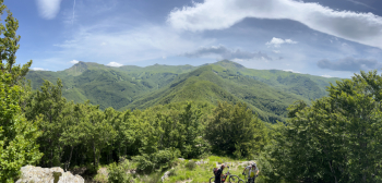
Fanano, Colombino, Pratignano

1 Downloads
0
 
Share
Author
Paoloc1
(79)
Place
Italy - Emilia-Romagna, MO
Km
36,25 km
Elapsed time
06:26:02
Vertical meters
+1 600 mt (525 - 1523)
Route difficulty
Landscapes
Last update
2025/06/03 08:14:42
Comments
0
Description

We start from TrePonti below Fanano and by asphalt climb to Fanano, Fellicarolo, up to Taburri. Here the dirt road begins with some challenging rips, first on forestry and then on single track up to Colombino Pass. Here you follow Cai 445 and then 419, the beautiful descent of Mirandola (from the homonymous ruins of the old village). Flow track at the beginning and poù technical in the final part, but always very smooth and fun.Then proceed to Ca dei Cani and take an old trail (poorly marked and beaten) that climbs (a short push section) to Ca Zucchi and from there by dirt road to Casellina and then by asphalt to Capanno Tassoni. From here take the 445 up to Passo della Riva; forestry and then trail with a few steep climbs (short push section) and then continue on the ridge with a few ups and downs until you reach Serra dei Baichetti (again a short push section).

Quick descent on trail and forestry to Pratignano Lake. Past the lake, on the dirt road you take the 403 on the right that heads towards CappelBuso, but we keep left and shortly after take the WarLine on the right: beautiful descent, with initial flow and then increasingly technical, with hairpin bends, rock steps, roots and steeps. Following the gps track, you arrive at Pianchette and from here on asphalt to Serrazzone. Short ascent to M.Luzzo and then final descent to TrePonti.


Download our free mobile app to send this route to your Garmin device or to navigate it on OSM maps. Android - iOS
Local weather
Oggi
23 °C
Stasera
16 °C
Domani
25 °C
Domani sera
17 °C
sabato
26 °C
Sabato notte
18 °C
domenica
23 °C
Domenica notte
16 °C
lunedì
23 °C
Lunedì notte
16 °C

Graph

Nearest Routes

31,85 km
Km
+1 457 mt
Vertical meters
Route difficulty
Landscapes
2023/06/21
- Italy - Emilia-Romagna, MO
ebsat
(115)
34,28 km
Km
+1 460 mt
Vertical meters
Route difficulty
Landscapes
2023/05/24
- Italy - Emilia-Romagna, MO
bonfi62
(11)
29,54 km
Km
+1 370 mt
Vertical meters
Route difficulty
Landscapes
2023/08/28
- Italy - Emilia-Romagna, MO
ebsat
(115)
35,15 km
Km
+1 612 mt
Vertical meters
Route difficulty
Landscapes
2023/09/30
- Italy - Emilia-Romagna, BO
Paoloc1
(79)
43,80 km
Km
+2 200 mt
Vertical meters
Route difficulty
Landscapes
2023/03/01
- Italy - Emilia-Romagna, MO
nonnocarb
(294)
33,06 km
Km
+1 500 mt
Vertical meters
Route difficulty
Landscapes
2023/03/06
- Italy - Toscana, PT
giobike73
(49)
36,98 km
Km
+1 727 mt
Vertical meters
Route difficulty
Landscapes
2023/03/04
- Italy - Toscana, PT
giobike73
(49)
37,20 km
Km
+1 860 mt
Vertical meters
Route difficulty
Landscapes
2023/05/25
- Italy - Emilia-Romagna, MO
bonfi62
(11)
31,66 km
Km
+1 650 mt
Vertical meters
Route difficulty
Landscapes
2023/04/28
- Italy - Emilia-Romagna, MO
bonfi62
(11)
40,80 km
Km
+1 777 mt
Vertical meters
Route difficulty
Landscapes

0 Comments