
 Italiano
 Deutsch
Lessinia Occidentale. L'ultimo baluardo difensivo della Grande Guerra

We are on the border between Veneto and Trentino, and the route runs along forest roads, groomed trails, a few short stretches of asphalt, and a few short stretches on uneven ground. Along the former border between the Kingdom of Italy and the Austro-Hungarian Empire. Starting at the parking lot of Passo Fittanze, at an elevation of 1399 meters, proceed by taking the trail in the direction of Malga Fittanze, taking care to keep the Malga on the right. Continue for about 600 meters along the path on the meadow and come to a fork, go down to the right and follow the asphalt road SP14 for about 1.7 km. Leave the asphalt and climb up a cart road to reach Malga Roccopiano and continue on the meadow for another 700 meters. Here you inevitably re-encounter the asphalt and follow it for a short distance (about 200 meters) and reach Bivio del Pidocchio.
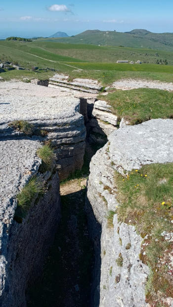
Go up to the left in the direction of Malga Lessinia and continue along the dirt road (which is still a provincial road). After 700 meters you reach Malga Lessinia, a former barracks of the Italian army during the First Great War. After another 500 meters you reach the Trenches of Malga Pidocchio, here it is worth stopping to visit them, trenches carved out by exploiting the rocky conformations of the ammonitic red, within which you can find observation points, and the "rooms" used as a kitchen/infermation/ammunition depot, etc. etc.
When the visit is over, continue the ascent along the provincial road, in the direction of Castelberto. At km 5.54 you reach a fork in the road, keep left in the direction of Castelberto and continue on the dirt road. After 800 meters you reach a second fork and proceed straight ahead. After another 280 meters you reach another fork with signs for Malga Foppiano, go straight again until the end of the dirt road, where there is an area with tables and benches. In addition to admiring the landscape, it is possible to leave the bikes and proceed on foot to the observation point, which is located a few dozen meters to the right.
Exactly below the observation point (nettles and claustrophobia permitting) there is a little surprise ;) On Mount Castelberto there is also the namesake Refuge, a former Austrian barracks. Once the visit/stop is over, you take your bike back and descend along the same road, to the junction for Malga Foppiano (from the benches it's about 450 meters), here begins a descent of 3 km and 400 meters of negative elevation gain (dose the brakes well, so as not to cook the pads). The bottom is averagely compact if covered with leaves, only a few short stretches with some stones, but nothing impossbilie. The descent ends in a grassy area where stands the beautiful Malga Foppiano, rarely open but very picturesque.
We continue by taking the forest road that starts behind the Malga and proceeds slightly downhill for another 600 meters until we come to a fork (we are at km 11.40), where we take a left with a 900-meter stretch of forest road that climbs rapidly (90 meters of elevation gain) We join a more beaten, proceed for 1.1 km uphill, until you reach the fork for Malga Revoltel/Rifugio Castelberto, keep right on the forest road, travel another 1.2 km to reach the second fork for Malga Revoltel, keep right and begin to descend until you reach the meadow of Malga Lavacchione. It is worth a stop here, because it is a really scenic spot. If you get there in early spring, with the meadow blooming with crocuses, it really is a spectacle of Nature!
Proceed downhill, following the forest road, which is cemented in places, until you reach the picnic area near the Faggio della Regina beech tree, about 1.3 km after Malga Lavacchione.
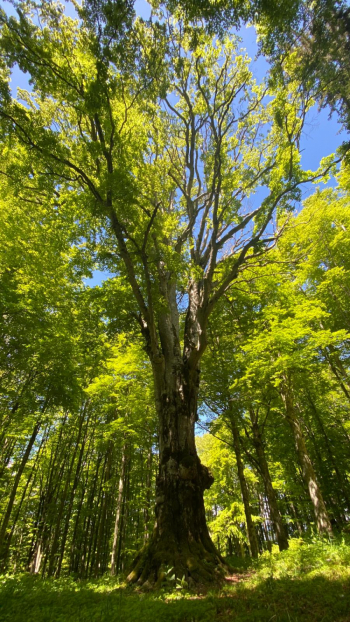
We are at km 16.60, on the right, somewhat hidden by the vegetation, there is a path that descends and leads to the Faggio della Regina, a monumental, fenced tree, with an estimated age of 250 / 300 years, worth a visit.
Descend along the path that serves as an impluvium, which runs alongside the beech, watch out for some exposed roots, then turn right and take the forest road again. Follow it for 840 meters, when on the left you will find a detour slightly uphill, passing by "Le ville" locality and skirting the Giuglio Mountain B&B, following it will take you to the junction on provincial road SP211. If you miss the detour, no problem, follow the forest road to the outlet on the asphalt, walk 30 meters and turn right on the small bridge. After the small bridge, turn right on asphalt for 750 meters and follow signs to Villaggio San Michele.
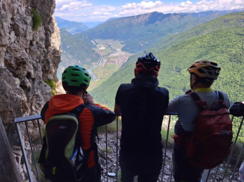
Keep right, here the asphalt becomes a dirt road, you skirt the campsite, at the fork for Malga Cime you keep right/straight and arrive at the gate from where an old military road begins, which in 2 km arrives at the famous "Busoni," the tunnels dug into the rock by the Royal Italian Army in 1916. You leave your bikes and equipped with a flashlight and helmet, you can visit, it is really worth it. There is only one room that is open and can be visited, giving you a breathtaking view of the Adige Valley below.
Coming out of the tunnels, you take your bikes back in the opposite direction, but after 60 meters, there is a detour on the right, here begins the most "difficult" part: a steep climb on loose stones and leaves, which after a few meters turns left, maintaining the slope. There is a slight esplanade near a double-entrance cave (on the right), here the trail descends slightly, then climbs steeply on grassy ground. Near the pylon the bottom becomes boulders, then flattens out soon after. You descend slightly into the prairie above Malga Cime, which you find on the left.
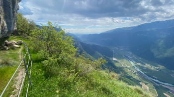
I recommend continuing along the prairie and arriving, with a final effort, to the edge of the woods on the right, where you leave your bikes again to visit Death Pass on foot. A place overlooking the Adige Valley below, with breathtaking views.
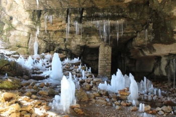
Back from Death Pass, you can backtrack to Malga Cime for a tasty lunch break (I recommend the malga gnocchi, accompanied by a craft beer). Now that you have recovered your energy, you strap on your bikes again and continue on the forest road that runs alongside the "Denti della Sega," it remains flat for about 1.5 km, after the second hairpin bend there is a 400-meter tear and average gradient of 20%, on a bumpy surface. Once passed, the slope decreases and leads to rejoin the asphalt at Col di Pealda Bassa. From here turn immediately right and take the dirt road that continues to climb to an altitude of 1520, then descend to Malga Preta di sotto (1485), take the path in the meadow that leads to the Cobbler's Cave. Also worth a visit here, with flashlight and helmet. In this cave it is possible to admire the ice stalactites and stalagmites that persist until late spring.
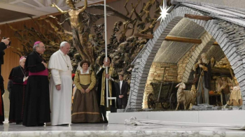
The return from the Cobbler's Cave is the same as the outward journey, you return to Col di Pealda Bassa, traveled a few meters of asphalt, take the second dirt road on the left, which makes the perimeter of Monte Cornetto, after about 2 km, at the end of a straight road, you can take a detour on the left and visit the Casaretta delle Fittanze, an old abandoned and semi-collected alpine hut, of which a made a reproduction exhibited in Sala Nervi in the Vatican, with the Nativity inside.
From the Casaretta you can follow the CAI meadow path, more fun than the dirt road, which will take you straight back to the Passo Fittanze parking lot, where the tour ends.
