
 Italiano
 Deutsch
Tour completo dell'Alpago

This route allows one to circum-pedal the entire Alpago, in a version, however, that is rather challenging both uphill and downhill.
Starting point is Farra d'Alpago at an elevation of 400 meters, northeast of Santa Croce Lake (small free parking lot next to the gymnasium, otherwise pay parking next to the sports facilities); the first ascent to Tambre is initially on asphalt, then veers to the right on a dirt road (immediately a short walk over landslide terrain). The climb has short but very challenging ramps. Reaching the village of Tambre (altitude 930 meters) finally a few meters of breathing space before embarking on the second part of the climb, also here on decidedly vertical ramps, to reach first malga Pian Grand, then the first GPM at altitude1370 meters. The subsequent abrupt descent ends on via Cate, from where we continue in the direction of the malga of the same name where refreshments can be found at the fountain.
Behind the malga begins the ascent to Val Salatis: the valley stretches southeastward, enclosed in a very impressive rocky amphitheater. Goal is casera Pian dele Stele (elevation 1425 meters), which is reached after 3.5km and 350 meters. It is not suggested -pedaling- to continue beyond the casera, because of the impractical trails (unless you are of cycling disposition).
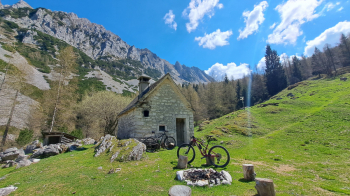
You return along the outward route, with a short variation on a more technical section to then enter a nice traverse with passages on scree toward Malga Pian Formosa. From here, first following the Alpago Natura itinerary and then deviating to the right on a forest ramp, via a steeply ascending path you proceed and reach Casera Crosetta (fountain behind the casera).
The next section allows you to definitely draw your breath, thanks to the long stretch that is practically flat until you reach the entrance to the climb to the Dolomieu al Dolada Refuge.
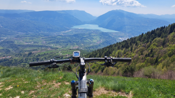
The climb, on asphalt, is 4 km long and climbs 450 meters to the 1500-meter elevation of the belvedere: exceptional is the view of the entire Alpago that opens up once you get above.
The descent is on beautiful trail in the woods with beaten bottom, some roots and nice tight hairpin bends to make it crisp, very few sections that require getting off the bike. The trail in the last part becomes decidedly narrow, with slaloms between trees but still on a smooth surface, a real treat. At the end of the descent, 500 meters further down, we proceed to the right to complete our Anello dell'Alpago on peremptory downhill forestry, interspersed further down with short climbs.
At the end of the forest road, at the entry on a small road towards Soccher, we choose to take the Sentiero dei Fortini in the direction of the hamlet of Casan (altitude 500 meters), then through some variants we avoid the asphalt until we reach the Via Regia/Monaco-Venezia bike path next to the Cellina canal, by which we return to Bastia and finally, via lakefront, to Farra d'Alpago.
