
 Italiano
 Deutsch
Doppietta Crocione + Gola di Lago

Combination of two rides in Capriasca. We begin with the long but steady, and totally paved, climb to the Crocione del Monte Bar. After 300 meters of elevation gain you take a small road with no traffic, while after 700 meters of elevation gain you are out of the woods and the fatigue of the climb is seasoned with the spectacular panorama of Lake Lugano. Panorama that becomes even more impressive when we leave the road and descend briefly on trail to the Crocione:
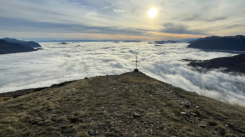
Our trail heads north, where on a clear day the entire Alpine arc can be seen:
Difficulty S1-S2, with a somewhat technical passage over a large rock. If you stay to the right you will find the best line. The path has been fixed lately, now it runs really well, without too many stones between the wheels.So we arrive at Davrosio, a farmstead where in summer you find all sorts of animals (also on the path), and we continue on the path to our left, with a first piece a bit tricky where you have to find the right line. Then it's all a succession of fast, slow sections, a few rips in the middle of the woods, all maximum S2.
Thus we arrive at Lelgio, where the second climb of the day begins, paved, up to Gola di Lago. The final section is steep and takes us almost to the top of the climb, which becomes unpaved. Once in the woods we follow a singletrack uphill, with a very cool fountain waiting for us almost at the top. From the highest point starts a nice traverse on singletrack that takes us up to Condra. We pass between houses and continue downhill, which becomes more rocky but, again, has been put in place. We come out at the parking lot and immediately turn left onto a path that is theoretically forbidden to bikes. During the week there is no one there, however, take care on weekends. There are, among other things, some rather challenging passages here that I would call S3. It is a slow trialist trail, if you want to avoid it continue the descent on the paved road, you will find the trail again.
In fact after arriving at the Bigorio convent the track goes up to the entrance of the last trail that takes us to Favessa: quite flowing, but with many loose stones in the initial part,it is also to be done carefully on weekends because of possible pedestrians.
We thus return to Tesserete where we conclude the tour.
