
 Italiano
 Deutsch
2025/02/18 14:28:44
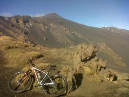
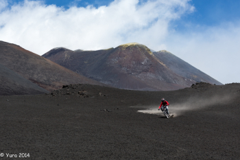
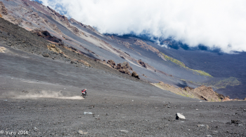
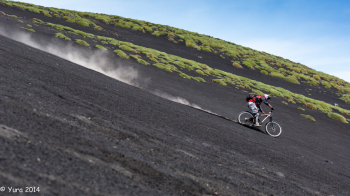
ETNA SUD 5: Rifugio Sapienza e i canaloni di sabbia
Author
Place
Italy - Sicilia, CT
Km
32,80 km
Elapsed time
00:00:00
Vertical meters
+1 324 mt (610 - 1889)
Route difficulty
Landscapes
Last update
2025/02/19 14:20:12
Comments
Description
This ride is characterized by a long asphalt climb starting from Zafferana Etnea (15 km and 1200 meters of elevation gain and with average gradient 8%), all of which will be repaid by a very long descent (15 km) very varied among sandy gullies and paths with loose stones among gorse forests and lava deserts (S0-S1) ending at the starting point. There are no extreme inclines but the terrain morphology lends itself to challenging riding.

Local weather

°C
°C
°C
°C
°C
°C
Graph
Nearest Routes
18,30 km
Km
+894 mt
Vertical meters
Route difficulty
Landscapes
2025/02/17
- Italy - Sicilia, CT 28,89 km
Km
+1 152 mt
Vertical meters
Route difficulty
Landscapes
30,39 km
Km
+1 117 mt
Vertical meters
Route difficulty
Landscapes
21,69 km
Km
+1 500 mt
Vertical meters
Route difficulty
Landscapes
2025/02/19
- Italy - Sicilia, CT 19,51 km
Km
+1 200 mt
Vertical meters
Route difficulty
Landscapes
18,40 km
Km
+791 mt
Vertical meters
Route difficulty
Landscapes
2025/02/17
- Italy - Sicilia, CT 18,03 km
Km
+792 mt
Vertical meters
Route difficulty
Landscapes
17,60 km
Km
+712 mt
Vertical meters
Route difficulty
Landscapes
22,25 km
Km
+1 063 mt
Vertical meters
Route difficulty
Landscapes
15,88 km
Km
+625 mt
Vertical meters
Route difficulty
Landscapes