
 Italiano
 Deutsch
Anello Levanto Framura e Bonassola

This route starts in Levanto where it is possible to find several white parking lots, especially out of season; in summer the situation is different. You go through the town center and take on the right the climb to the Guaitarola pass, about 600 meters of elevation gain on rideable asphalt. Once at the top and off the top, you can fill your water bottle at the cyclist drinking fountain. Continue and at the junction with the Bracco road take a left, after a few hundred meters turn right towards San Nicolao, a steep climb that never lets up. When you reach the top you take the Rai corta trail that is always well maintained . Go back to the road from the bracco and take a left towards the Guaitarola Scollinato, take on the right the dirt road that leads towards the two small pistes called Castagnaccio, in this track has been walked twice the one on the right and once the one on the left, they deserve and the climb is very short. At the end of the left chestnut track you keep left on dirt track that then becomes a fast single track in the woods. Eventually you come to a clearing where on the right you take the Gaggi 4 trail, which has just been fixed and is very nice. You end up on asphalt and take a left, after a few hundred meters you go down to the right on asphalt and then immediately left on a trail overlooking the sea.
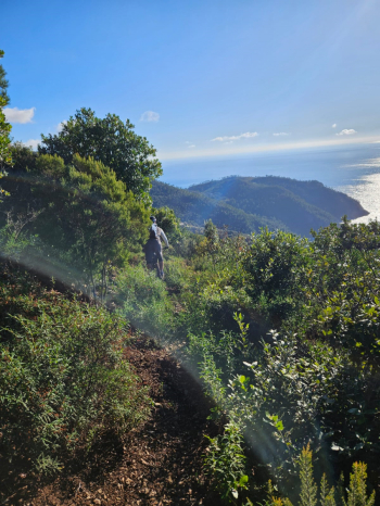
The path is very narrow and the vegetation thick, but it is all cyclable and the views are breathtaking. At the end of the trail you take a left and start a long eat and drink, remember to keep some energy for this unforgiving piece. So you arrive at the leap of the hare, a promontory that separates Bonassola and Framura, here you descend to Bonassola where with the comfortable bike path by the sea you return to Levanto and the car.
