Italiano
 Deutsch
Giro dei forti

Depart from the village of Ossana and ascend along the old road leading to Passo del Tonale, pass through the Centro Fondo di Vermiglio pleasant little lakes sports area, follow the cross-country track in the direction of Volpaia then continue on dirt road that climbs in the direction of Velon. After the bridge over the Vermigliana stream, climb to the left in the direction of Maso Cadin, alongside the ruins of old military barracks from the 1914-1918 War.
Past the farmsteads, continue to the right along a small road until it crosses the dirt road that goes up to Fort Tonale. Follow it downhill for 100 meters and on the left you will soon reach near the beautiful Velon hut, past which the road gradually climbs in the direction of Passo Tonale; passing first the stream and then still on the level amid some clearings you will reach the Malga Pecè.
During World War I the malga was home to an Austro-Hungarian sub-commando. The older plants surrounding it still bear the shrapnel of Italian shells. Past the malga the compact road, often crossed by streams, climbs through dense fir forest. After a few hairpin bends the forest thins out, allowing a view of the valley, and after a few steep climbs you reach the vicinity of State Road No. 42. Just before it, turn left uphill in the direction of Località Cantiere Presena and after one km, on the right, continue along a path-life trail (?Sentiero della Pace?) crossing the slopes and reaching Passo Tonale.
Recommended is a visit to the Ossuary, built in 1924, which contains the remains of 831 soldiers who fought in the Tonale area; here is the border with Lombardy, once the state border with the Kingdom of Italy.
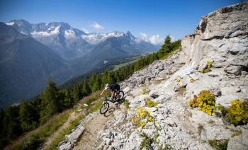
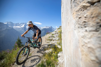
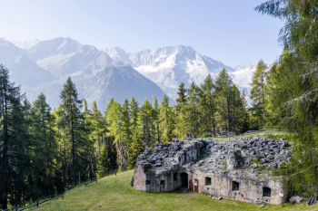
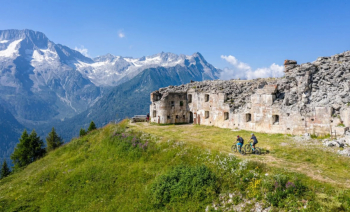
Follow SS. No. 42 for a hundred meters to the Adamello Ski ticket office located on the other side of the road; from here take a small road, in some sections rather steep, in the direction of Malga Cadì - Ospizio San Bartolomeo (1.971 m - the hospice built perhaps as early as 1127 and governed by a prior, gave hospitality and refreshment to passers-by) crossing the bike park and from there on the flat again in the direction of Val di Sole along the high mountain meadows in the presence of the imposing icy peaks of Presanella. A slight descent leads to the ruins of the former Fort Mero (1,841 m - picnic area), surrounded by a beautiful larch forest, which with Forts Tonale, Strino, Zaccarana and Pozzi Alti (built in the late 1800s and early 1900s) formed the defense belt of the Habsburg Empire, with numerous cannons, mortars and machine guns. The road continues with a few ups and downs to reach a junction from which on the left you can climb to the former Fort Zaccarana (2,026 m - about 40 minutes) located in a dominant position on the slopes of Mount Tonale Orientale. You descend again, continuing beyond the crossroads, entering the Strino Valley after a slight descent until you cross a small road at the bottom of the valley that leads to Malga Strino. Continue slightly uphill for a short distance until you come to a fork in the road that leads to Masi di Strino-Malga Mezzolo on the right, after crossing the Rio Strino following the slopes of the mountain.This is a very scenic site where you can see the Adamello-Presanella ridge on the opposite side. At the end of the forest road you can admire a glimpse of the Val di Sole and then enter a rather challenging slightly downhill path to Val Verniana. Cross the brook and turn right skirting the meadows until you reach the farms of the same name; at the last hut, take the forest road uphill again to Val Saviana and continue on a path (about 600 meters) that leads to cross the brook and the meadows.
Continue uphill to the left heading to Malga Boai, then a descent leads to the forest road that on the coast replaces the path. From here you can admire the beauty of the peaks on the opposite side that descend from Tonale down the Val di Sole. Downhill, along the forest road, you reach the valley floor and pass through the historic center of Cortina. You take the "pendege" road and through an up and down climb you return to Fucine di Ossana.