HOME RANKINGS CHALLENGES ROUTES POI PLANNING SEARCH LOGIN
Italy - Trentino-Alto Adige/Südtirol, TN
2024/09/14 16:41:04

Larici secolari: la presa in giro trentina

0 Downloads
0
 
Share
Author
Staff
(75)
Place
Italy - Trentino-Alto Adige/Südtirol, TN
Km
22,04 km
Elapsed time
02:08:14
Vertical meters
+1 064 mt (812 - 1799)
Route difficulty
Landscapes
Last update
2024/09/21 12:36:48
Comments
0
Description

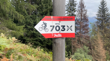
This route is listed on the Val di Sole website as an official MTB tour with trail descent. Since we are in Trentino and all trails "narrower than a MTB put sideways" are forbidden by law, you know what to expect for the descent: a mule track passed off as a "technical and long single track."

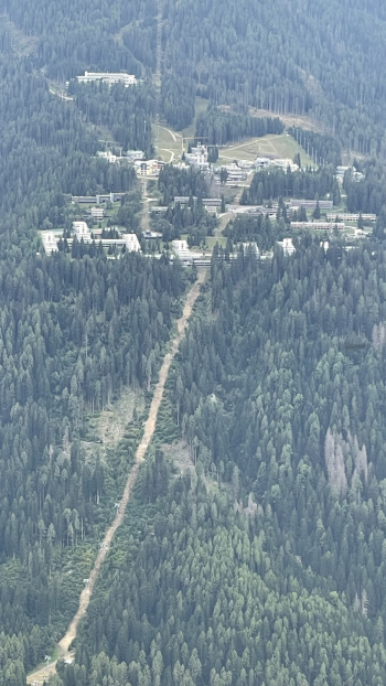
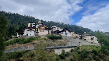
You start from the parking lot of the Daolasa cable car, the Black Snake one for short. You follow the bike path until you cross State Road 42 and ascend toward Termenàgo-Ortisé-Menàs on a little-used asphalt road that passes the villages of Termenàgo, Ortisé, arriving at Menas (1517 meters) with a constant gradient.

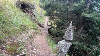
Once past the village, take at a fork the dirt road to the right that first on the flat then uphill reaches the Malga del Monte Bassa. There I saw at least four nice aggressive dogs, fortunately all chained up. I dare not imagine at night when they are free to defend the flocks and cows.... One more stretch on a dirt road to reach the beginning of the path of the ancient larches, where initially you have to push the bike and then begins a nice traverse that passes these magnificent trees.

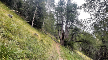
Thus begins the descent, the ugliest part of the tour: it is a mule track full of stones driven into the ground, very steep, with no difficulty whatsoever except for your brakes that will scream for mercy until you reach Mestriago, exactly on the opposite side of the river from where we started. We eat up all the elevation gain in no time and the fun is zero. You have been warned. If you have an ebike do the mule track uphill, at least you risk having fun.

Note that on the opposite side they have no problem giving permits to create an ecomoster in the name of snow that is not there.


Download our free mobile app to send this route to your Garmin device or to navigate it on OSM maps. Android - iOS
Local weather
Tonight
10 °C
Tomorrow
13 °C
Tomorrow night
12 °C
Sunday
16 °C
Sunday night
10 °C
Monday
17 °C
Monday night
9 °C
Tuesday
16 °C
Tuesday night
10 °C
Wednesday
15 °C

Graph

Nearest Routes

2024/09/14
- Italy - Trentino-Alto Adige/Südtirol, TN
Staff
(75)
30,51 km
Km
+1 046 mt
Vertical meters
Route difficulty
Landscapes
2024/09/14
- Italy - Trentino-Alto Adige/Südtirol, TN
Staff
(75)
18,55 km
Km
+562 mt
Vertical meters
Route difficulty
Landscapes
2024/09/14
- Italy - Trentino-Alto Adige/Südtirol, TN
Staff
(75)
11,72 km
Km
+11 mt
Vertical meters
Route difficulty
Landscapes
2024/09/14
- Italy - Trentino-Alto Adige/Südtirol, TN
Staff
(75)
29,33 km
Km
+617 mt
Vertical meters
Route difficulty
Landscapes
2024/09/14
- Italy - Trentino-Alto Adige/Südtirol, TN
Staff
(75)
12,00 km
Km
+11 mt
Vertical meters
Route difficulty
Landscapes
2024/09/14
- Italy - Trentino-Alto Adige/Südtirol, TN
Staff
(75)
66,22 km
Km
+2 400 mt
Vertical meters
Route difficulty
Landscapes
2024/09/14
- Italy - Trentino-Alto Adige/Südtirol, TN
Staff
(75)
66,56 km
Km
+1 900 mt
Vertical meters
Route difficulty
Landscapes
2024/09/14
- Italy - Trentino-Alto Adige/Südtirol, TN
Staff
(75)
3,18 km
Km
0 mt
Vertical meters
Route difficulty
Landscapes
2024/09/14
- Italy - Trentino-Alto Adige/Südtirol, TN
Staff
(75)
31,82 km
Km
+1 357 mt
Vertical meters
Route difficulty
Landscapes
2024/09/14
- Italy - Trentino-Alto Adige/Südtirol, TN
Staff
(75)
28,74 km
Km
+1 343 mt
Vertical meters
Route difficulty
Landscapes

0 Comments