HOME RANKINGS CHALLENGES ROUTES POI PLANNING SEARCH LOGIN
Italy - Lombardia, SO
2024/08/30 17:00:13

Bei Laghet - Santa Caterina Valfurva

9 Downloads
1
 
Share
Author
marco
(124)
Place
Italy - Lombardia, SO
Km
26,05 km
Elapsed time
02:15:27
Vertical meters
+301 mt (1200 - 3007)
Route difficulty
Landscapes
Last update
2024/08/30 21:31:33
Comments
0
Description

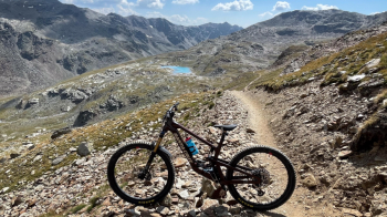
A classic in the Bormio area. It goes up by cable car to Cima Bianca at 3,012 meters (Bormio 3000 cable car, prices here). From here a 10-km trail starts, passing through different mountain environments. Initially it descends on a scree slope. The trail has been cleared well of boulders, so you arrive without major problems at the beautiful Bei Laghet (maximum difficulty: S2).

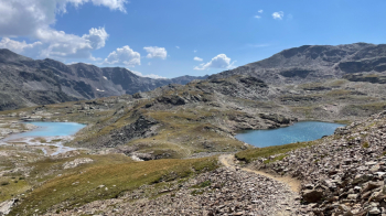
The turquoise color, if I am not mistaken, is due to algae in the water. I took the 1:30 pm cable car on August 30 and found myself completely alone because the few pedestrians were returning to the cable car.

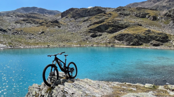
Having taken the customary photos, the descent to Santa Caterina Valfurva began, first over some large grassy meadows....

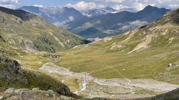
..interspersed with a passage on rock with some small technical sections. Then you arrive in the woods, where first you pedal and push uphill for about 150 meters of elevation gain, then you descend rather steeply on a beautiful singletrack that has S3 passages due to erosion. You come out at some huts, where you take a cart track that at one point becomes steep and overgrown with boulders: maintenance this unknown. It will throw us off onto a dirt road, just above Santa Caterina Valfurva, which we will follow to the village.

From here, to return directly to Bormio, we have no choice but to follow the paved road. At S. Antonio we will abandon it to take the bicycle path on the right side of the river and return quietly to Bormio.

Download our free mobile app to send this route to your Garmin device or to navigate it on OSM maps. Android - iOS
Local weather
°C
°C
°C
°C
°C
°C
°C
°C
°C
°C

Graph

Nearest Routes

2024/08/31
- Italy - Lombardia, SO
marco
(124)
24,33 km
Km
+339 mt
Vertical meters
Route difficulty
Landscapes
2022/08/10
- Italy - Lombardia, SO
steve-U
(23)
51,88 km
Km
+3 385 mt
Vertical meters
Route difficulty
Landscapes
2023/08/16
- Italy - Lombardia, SO
TeoBonfa
(5)
38,83 km
Km
+1 200 mt
Vertical meters
Route difficulty
Landscapes
2023/09/14
- Italy - Lombardia, SO
38,71 km
Km
+2 134 mt
Vertical meters
Route difficulty
Landscapes
2022/11/06
- Italy - Lombardia, SO
36,20 km
Km
+1 141 mt
Vertical meters
Route difficulty
Landscapes
2022/11/07
- Italy - Lombardia, SO
21,01 km
Km
+730 mt
Vertical meters
Route difficulty
Landscapes
2022/11/13
- Italy - Lombardia, SO
18,25 km
Km
+1 200 mt
Vertical meters
Route difficulty
Landscapes
2024/05/23
- Italy - Lombardia, SO
Staff
(72)
45,60 km
Km
+1 500 mt
Vertical meters
Route difficulty
Landscapes
2023/08/25
- Italy - Lombardia, SO
Maxone1
(10)
26,76 km
Km
+1 500 mt
Vertical meters
Route difficulty
Landscapes
2023/08/22
- Italy - Lombardia, SO
Maxone1
(10)
15,44 km
Km
+1 000 mt
Vertical meters
Route difficulty
Landscapes

0 Comments