HOME RANKINGS CHALLENGES ROUTES POI PLANNING SEARCH LOGIN
Italy - Friuli-Venezia Giulia, UD
2024/07/30 15:06:05

Sorgenti Piave - Rifugio Calvi - Passo Sesis - Monte Oregone - CAI134 - Val Visdende - Orrido dell'Acquatona

2 Downloads
0
 
Share
Author
civi65
(105)
Place
Italy - Friuli-Venezia Giulia, UD
Km
38,42 km
Elapsed time
07:38:57
Vertical meters
+1 440 mt (1075 - 2411)
Route difficulty
Landscapes
Last update
2024/07/31 10:52:38
Comments
0
Description

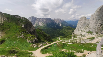
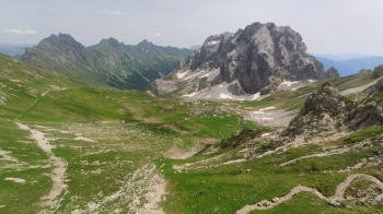
Cyclo-mountaineering route with ascent on asphalt to Piave springs, on very steep cemented and unpaved road to the Calvi refuge, on shoulders to the Sesis pass, on pedaled path to the former barracks at Oregone pass, on shoulders to the summit of Mt. Oregone, descent on little pedaled CAI134, unpaved and paved road in Val Visdende to close the loop.

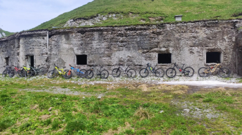
Start in Sappada, climb on asphalt to Cima Sappada and on busy medium-steep asphalt to the headwaters of the Piave River, from which begins the very steep cemented and dirt moved climb to the Calvi hut, splendid panorama. You load the MTB on your shoulders and climb on moved gravel to Sesis Pass, beyond which you briefly shoulder left and then pedal on super scenic trail to Oregone Pass, at the former finance barracks, from which you briefly shoulder up to the summit of Mt. Pamorama 360° over the dolomites and descend on loose rocky bottom, then take CAI134 rich in vegetation and not at all frequented, with many exposed spots, particularly in the impluviums, with earth bottom hidden by the abundant vegetation. Not very rideable but very rewarding for the views. Last fun but short part, then on dirt road that has swept away the paths after the logging of Vaia, which gives no room for other digressions, then take the asphalt road that climbs at medium gradient to the little bridge of the Orrido dell'Acquatona, from which you climb a little to descend on dirt road along the Piave and on the asphalt bike path that in a few km leads to Sappada.

Download our free mobile app to send this route to your Garmin device or to navigate it on OSM maps. Android - iOS
Local weather
Today
5 °C
Tonight
-5 °C
Tomorrow
6 °C
Tomorrow night
-1 °C
Tuesday
6 °C
Tuesday night
2 °C
Wednesday
6 °C
Wednesday night
0 °C
Thursday
6 °C
Thursday night
-5 °C

Graph

Nearest Routes

2023/03/02
- Italy - Friuli-Venezia Giulia, UD
civi65
(105)
28,22 km
Km
+1 230 mt
Vertical meters
Route difficulty
Landscapes
2023/03/07
- Italy - Friuli-Venezia Giulia, UD
civi65
(105)
21,78 km
Km
+1 470 mt
Vertical meters
Route difficulty
Landscapes
2022/10/13
- Italy - Friuli-Venezia Giulia, UD
civi65
(105)
21,11 km
Km
+1 394 mt
Vertical meters
Route difficulty
Landscapes
2022/10/02
- Italy - Friuli-Venezia Giulia
31,66 km
Km
+1 577 mt
Vertical meters
Route difficulty
Landscapes
39,52 km
Km
+1 550 mt
Vertical meters
Route difficulty
Landscapes
67,78 km
Km
+2 000 mt
Vertical meters
Route difficulty
Landscapes
48,76 km
Km
+2 100 mt
Vertical meters
Route difficulty
Landscapes
2022/09/27
- Italy - Friuli-Venezia Giulia, UD
civi65
(105)
30,18 km
Km
+1 628 mt
Vertical meters
Route difficulty
Landscapes
2023/03/09
- Italy - Friuli-Venezia Giulia, UD
civi65
(105)
15,42 km
Km
+1 100 mt
Vertical meters
Route difficulty
Landscapes
2023/03/10
- Italy - Friuli-Venezia Giulia, UD
civi65
(105)
34,76 km
Km
+1 700 mt
Vertical meters
Route difficulty
Landscapes

0 Comments