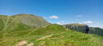
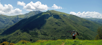
Passo Del Cancellino, Segavecchia, Monte Grande, Fiammineda
For our first in the Apennines we decide to christen 2024 with an itinerary among those that I consider the most beautiful and varied that can be found in the Corno alle Scale area. Early in the morning we park the car in Pianaccio, a small village not far from Lizzano in Belvedere (Bo), famous for being the birthplace of Enzo Biagi.We get on our bikes and head toward the Segavecchia refuge, from where the first long climb will begin that will lead us to Passo del Lupo. Once we reach the latter we will abandon the forestry road in favor of the Cai 111 trail, and having crossed the Cai 205 we continue in the direction of the Portafranca refuge.
Without stopping, we continue on the same path until we reach the Fonte dell'Uccelliera spring where we continue on 00 in a nice traverse at the foot of Mount Gennaio until we reach the Cancellino Pass, where the first ascent of the day ends. We stop just long enough to munch something and get dressed for the descent that will take us back to the Segavecchia refuge on Cai 121.The trail is simply fantastic, very varied, quite fast in the upper part and very technical on the final part. Now we get the second and toughest climb of the day, initially quite steep, then as we climb it softens a bit while still maintaining a good gradient. Arriving at the Sboccata dei Bagnadori, instead of bypassing Monte Grande, we decide to cross it by climbing to the summit.
The climb is very easy, rideable in parts and certainly doable almost entirely by e-bike, except for the very steep but short final section that leads to the summit marked by a large stone where a faded inscription indicates the name and altitude.The view is very beautiful, in front of us stand out the summit of Corno alle Scale (Punta Giorgina) and the Nuda, conquered a few years ago with no small effort. We prepare for the unknown of the descent hoping that it is cyclable or at least a good part of it.
The start suggests that it is, but after a first part that is really enjoyable, we immediately have to change our mind, as we have to overcome a rock jump to do on foot. Fortunately this is only a short stretch, the remaining descent is once again feasible all on the saddle up to the Bocca delle Tese where we take the Cai 151 trail and continue an exciting descent to Pianaccio, passing through the abandoned village of Fiemmineda.


 Italiano
 Deutsch