HOME RANKINGS CHALLENGES ROUTES NEAR ME PLANNING SEARCH LOGIN
Switzerland
2024/06/01 09:03:25

Moschera con salita su trail

5 Downloads
2
 
Share
Author
marco
(131)
Place
Switzerland
Km
15,11 km
Elapsed time
01:36:53
Vertical meters
+749 mt (516 - 1184)
Route difficulty
Landscapes
Last update
2024/06/01 09:24:43
Comments
0
Description

Short but intense ride above Tesserete, with descent entirely on trails. Go up a small paved road to Bigorio and continue to the convent of the same name. Continue to a barrier, where the road continues dirt or cemented with steep sections to Condra. From here you take a false-flat path and follow it to a fork to the left, where it gets really steep but those with legs do it completely in the saddle even without the need for the motor. You come out on a dirt road that you follow to the left and that with a few steep ramps takes you to the Moschera meadows. You follow the path for 300 meters that takes us to the summit of the large stone cairn.
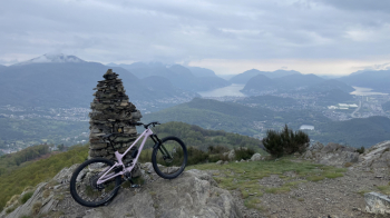
From here take the path that takes us first to Condra, then to the parking lot of the same name and then to the Bigorio convent (slow and technical stretch, avoidable if you continue on the paved road). Short climb to take the last trail of the day (Favessa), very rocky at first but then smoother that brings us back near Tesserete. #lugano

Download our free mobile app to send this route to your Garmin device or to navigate it on OSM maps. Android - iOS
Local weather
°C
°C
°C
°C
°C
°C
°C
°C
°C
°C

Graph

Nearest Routes

2024/10/14
- Switzerland
marco
(131)
26,36 km
Km
+1 372 mt
Vertical meters
Route difficulty
Landscapes
2023/07/28
- Switzerland
marco
(131)
40,99 km
Km
+1 853 mt
Vertical meters
Route difficulty
Landscapes
2022/09/02
- Switzerland
marco
(131)
18,82 km
Km
+887 mt
Vertical meters
Route difficulty
Landscapes
2022/08/10
- Switzerland
marco
(131)
36,02 km
Km
+1 266 mt
Vertical meters
Route difficulty
Landscapes
2023/06/12
- Switzerland
CrisB
(4)
29,90 km
Km
+1 336 mt
Vertical meters
Route difficulty
Landscapes
2024/06/01
- Switzerland
marco
(131)
17,98 km
Km
+849 mt
Vertical meters
Route difficulty
Landscapes
2022/12/21
- Switzerland
marco
(131)
17,99 km
Km
+962 mt
Vertical meters
Route difficulty
Landscapes
2024/06/01
- Switzerland
marco
(131)
30,49 km
Km
+1 300 mt
Vertical meters
Route difficulty
Landscapes
2022/10/15
- Switzerland
marco
(131)
39,86 km
Km
+1 729 mt
Vertical meters
Route difficulty
Landscapes
2022/09/28
- Switzerland
marco
(131)
16,08 km
Km
+756 mt
Vertical meters
Route difficulty
Landscapes

0 Comments