Italiano
 Deutsch
I giganti della Val d'Arda (PC)

Cyclo-hiking route that winds over the summits of the Menegosa, Lama, Groppo di Gora and Rocca dei Casali Mountains in the Upper Arda Valley in the province of Piacenza bordering that of Parma. One of the most beautiful areas in Piacenza for hiking. There are several backpacking bike sections near the tops of the mountains, and the descents from Mount Menegosa and Groppo di Gora are difficult even on foot.
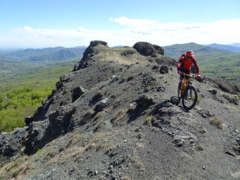
The start is from the picnic area (there is only one table in the tall grass) near the Arda stream near the village of Salino di Pedina. It climbs gradually first on asphalt and then on dirt road. The last 150 meters of elevation gain before the saddle of Mount Menegosa are by bike on the shoulder. Turning left you reach the Cima di Morfasso (one of the peaks of Mount Menegosa), with the last section with bike on shoulder among the rocks. Back to the saddle, very short push section to pass over a photogenic ridge with overhangs on either side.
The descent is very tricky, with rock steps and lots of boulder. Pay attention even if done on foot. We arrive on the CAI trail coming from the Santa Franca Pass where you can ride even if it is ruined by motorcycles in some sections.
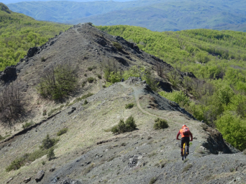
We arrive at a fork where we take the path that indicates Monte Lama, it is the most direct and vertical route. Initially you pedal, then push and then carry. We arrive on the summit pastures of Monte Lama, a balcony over the valley and the peaks of the nearby Emilian Apennines. The descent from Mount Lama is cyclable and not difficult. We return uphill partly pushing the bike as we pass under Castellaccio, another ophiolitic formation in the area.
Alternating between pedaled and pushed sections we arrive at the slopes of Groppo di Gora, another hyper panoramic relief over the Parma valleys. Pay attention in this section to the exposure, which is truly remarkable (Madonnina section). The descent from the Groppo di Gora is very difficult, steep, hollowed out and with uneven ground until you reach the beech forest.
Now on nice path among the beeches we come to cross a dirt road that follows a methane pipeline. We turn right on a nice path that, however, has several puddles due to the passage of motorized vehicles. On a fast mule track we arrive at the asphalt of the Provincial Road that we follow until the village of Casali. We climb to the top of Rocca dei Casali on a nice path that we will also use for the return.
On the way down we noticed a path with several stone cairns at the beginning that leads to the end point of the cliff climbs. The path is very narrow, again an out-and-back. We lose elevation on a stony mule track until we find the asphalt and later the cars. Although the itinerary does not present significant heights, it should be tackled only if one does not suffer from exposure and with sure footing in the walking sections especially on Mount Menegosa. It is not a route suitable for pedalers and e-bikers. Not feasible in wet weather.
You can get an idea of the beauty of the places and the uniqueness of the route by reading the report.