Anello del Matanna e cresta del Belvedere
From Mulina, in front of the bar trattoria da Luciana, we head toward Stazzema, which we do not reach by leaving the main road on a hairpin bend at an altitude of 400. We continue to climb until we reach the small B&B Casa Giorgini where we go to catch up with Cai 6 towards Fonte Moscoso. Having filled our water bottles with fresh water we abandon Cai 6 in favor of 8 and alternating between pushing and a few pedal strokes we arrive at the mouth of the Porchette. We sketch a first easy descent and still on the same path we reach the locality of Il Cerro.
We resume the ascent on a paved road passing through Palagnana and arrive at Bucine, distinguished by its beautiful bell tower placed on the edge of the road that climbs from Pascoso to reach Alto Matanna and where we are also headed. When we arrive at the refuge we allow ourselves a brief stop before tackling a short bike ride to reach the crest of Mount Matanna by cutting through meadows near Bozzone. At an altitude of about 1140 we begin a nice downhill traverse passing under the summit of the mountain mostly entirely rideable and after a short relaunch we reach the Belvedere from where the ridge line we will follow will begin.
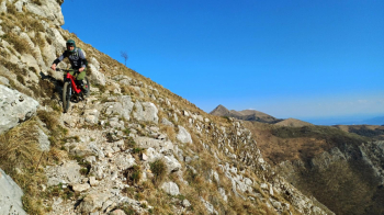
The descent is never borderline although not to be underestimated and the environment is truly beautiful. At about elevation 900 we cross the Cai 3 which we ignore continuing to descend this time on a less visible but still obvious trail and the environment wilder.
At elevation 750 the trail bends northward and after a short while begins to climb to rejoin Cai 3 in the direction of Foce di San Rocchino. Still following 3 we reach Fornocchia with a nice eat and drink, where we finally return to descend on the recently cleared SAV Trail (Sentiero alta Versilia (high Versilia trail) that leads us to our starting point.


 Italiano
 Deutsch