Italiano
 Deutsch
Bigorio Trails

A short but challenging route, ideal for days with Föhn, the north wind that sweeps through the Ticino mountains when it is bad north of the Alps. If you are interested in how this wind comes about, click here.
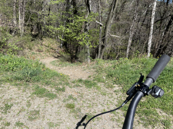
From the Tesserete sports field (parking fee), the trail climbs up toward Bigorio, passing through the pretty village and reaching the monastery of the same name. The paved path is quite steep, but well shaded and sheltered from the wind. Even in winter it is warm because the location faces south. We reach the end of the paved road, pass the barrier and continue up the dirt road, whose steep sections have been cemented. Here the wind begins to pick up, fortunately it is blown on our rear almost at the end of the climb at a hairpin bend, helping us to finish the climb. A short ramp to the trailhead and we are off in the direction of Condra. Mind you, from here on all trails are also used by pedestrians, especially on weekends, so no searching for the KOM or other such crap.
The descent from Condra is just new, there are steps, a few tight turns and some boulders. It throws us off at the parking lot where the little road we took uphill ends. We pass the bar again, climb up the first concrete ramp, continue for a while and, before resuming the climb, take a path to the right. This could theoretically be smooth, the problem is that it is cleaned from time to time, so you have to be careful of many boulders on the ideal line. The technical passages are all doable in the saddle; if in doubt, dismount and take a look before tackling them. Watch out for rocks that are just waiting to crush your tires.
You then arrive in Bigorio. We cross the village slowly, because the narrow lanes (without cars) are narrow and people live in them. At a cool fountain, we take the road back up and pedal to reach the final descent, past the monastery. It is called Favessa and is a bit bumpy and rocky in the first part, but the further down you go, the smoother and more fun it becomes. Your suspension will work like crazy. Again, be aware that there are a lot of people around.
Descend just above Tesserete and return to the sports field. If you want a drink, there are several bars downtown.