Italiano
 Deutsch
Piana & Spranga, Apuane meridionali

The complex of Mount Prana or Prano offers several more or less complicated variants in a very particular environment that at first glance may seem simple but instead hides many pitfalls. The terrain is very disparate with not very visible pathways, very not recommended on days with low visibility. Today I propose a very beautiful itinerary both from a scenic and playful point of view, to be tackled with due physical preparation.
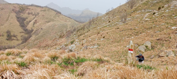
Leaving Camaiore, we head towards the small village of Casoli, famous for its Murals, and continue towards Trescolli. Shortly after the Kiosk in the Woods we turn right on a steep asphalt climb but which shortly after becomes a wide cobbled path that forces us to push our bikes so as not to waste energy unnecessarily.Before arriving at the mouth of San Rocchino we glimpse a path with Matanna indications that allows us to make a cut and recover Cai 3 more or less at the Foce di Grattaculo.From here we continue almost entirely in the saddle to the slopes of Mount Matanna where the trail comes out of the woods and with a beautiful traverse continues to the Foce del Pallone, where a first short section with a backpacking bike will be necessary. Just below the mouth we detach from the trail to follow the traverse a little further down and resume pedaling until we cross Cai 101, where we face a first short descent that ends at the Foce del Termine.
Still following the 101 we reach Campo all'Orzo in a succession of pedaled stretches to others downhill, we continue without stopping and reach the end of the trail passing the remains of Mirabello. Reaching the road that climbs from Passo Lucese, we resume the ascent to the small Rifugio Casa del Maestro, crossing a short stretch of very suggestive fir forest. Unfortunately, the hut is closed today so we decide not to stop and continue on our way. From here you can choose between the destinations of Mount Prana or Mount Pedone, the junction is just above the hut and a little further in the direction we have chosen there is a spring where you can get water before tackling the climb up the ridge whatever you have chosen.
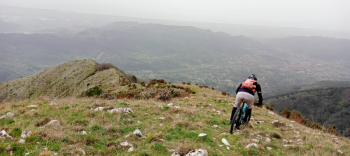
Unfortunately, from now on, except for small sections, you have to continue with bike in tow, pushing it or loading it on your shoulders basically until you reach the summit of Mount Piana, the highest point of our hike.If it weren't for this very strange Saharan sky, we would have a beautiful and majestic view despite the altitude not being of the most important ones. We begin the descent by a beautiful ridge all completely cyclable on a grassy bottom seasoned by a disctreta amount of rocks that, however, do not raise any kind of concern.The crazy ride continues for a long stretch until we reach the summit of Mt. Spranga, another hundred or so mentri then the trail gets nasty steep and narrow with outcropping rocks and forces us to carry the bike for about 150 meters of elevation gain. In a few stretches I try to sketch a timid ascent in the saddle, but after a stretch that seems doable comes another one definitely out of my comfort zone.We finally arrive at the end of this ravine, on the path from the White House that would continue to Buchignano, but be careful because we have to descend just below to take another one that takes us directly to Torcigliano. The stretch is short but noteworthy, a couple of technical passages and two three close and very narrow hairpin bends.
Once in the village, we cross the narrow streets, catching sight of a few murals, follow the Camaiore streets path for a stretch, and once in Buchignano we finish the tour with a small path to the village of Nocchi, where we recover the asphalt and head towards the Camaiore Stadium where we had parked in the morning.
The ride is classified as very difficult for the steep ridge to be done on foot with bike in tow after Mt. Spranga. Not recommended for assisted bike owners unless you are used to such situations and contemptuous of fatigue.