Italiano
 Deutsch
Val Serviera
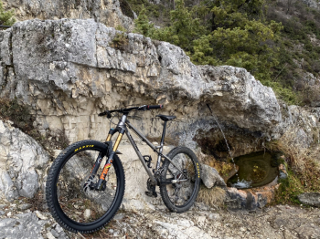
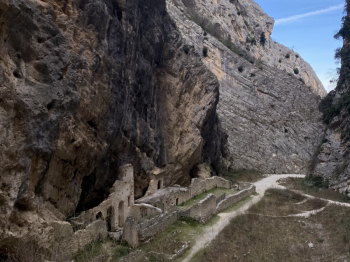
We start from Fara San Martino and via the G3 trail we arrive at Capo Le Macchie. The climb immediately starts very steep and it is impossible to pedal from the very beginning. At the junction with the G6 trail we turn left to take the latter and begin the very long and at times very hard ascent alternating between portage and push pieces. After about 4 hours of hostility we arrive at the key point of the tour, the Callarelle Cave, a beautiful cave that is used by shepherds as a shelter and recently equipped as a bivouac. From here you continue to climb and after tackling an almost climbing section you finally reach the beginning of the descent. Passages on fixed rock, tight switchbacks, bouldery sections and exposed sections make this part really exciting. After a couple of short climbs in the final part, the G6 gives up a bit until the intersection with the H1. From here, after a fairly quiet first part, the good stuff begins. The trail gets rough and a series of really hard passages begin, for those unfamiliar with them I recommend studying them before attempting them. Steep, narrow, bumpy and fixed, there really is everything. This last section has numerous S4 passages and requires triallistic skills to be tackled at its best. In addition to being exciting on a technical level, the final trail is also a spectacle on a scenic level. You descend inside a gorge surrounded by hundreds of meters high rock walls, the last passage is really incredible, about a couple of meters wide also wrapped by very high rock walls. One of the most beautiful loops you can do on the Majella and probably on the entire Apennines. A very hard ride and suitable only for asocial bikers who don't mind pushing and carrying their bikes on their shoulders, yeah because of the 1,600 meters of elevation gain, there is virtually no pedaling. There are also several passages to be done almost climbing helping yourself with your hands so I recommend the ride only to lovers of the genre and I do not recommend it to ebikes, because in several places you have to put the bike on your shoulders. You will be rewarded by a sublime environment of rock walls, caves and chamois in abundance and of course a spectacular descent. Also not for everyone, very technical, with S3 grade and many S4 passages that require advanced balance and riding skills if you want to get the upper hand.