2024/01/07 16:39:41
Capri + Speedyfunny
Author
Place
Italy - Piemonte, BI
Km
4,79 km
Elapsed time
00:30:03
Vertical meters
+250 mt (443 - 697)
Route difficulty
Landscapes
Last update
2024/01/07 17:07:53
Comments
Description
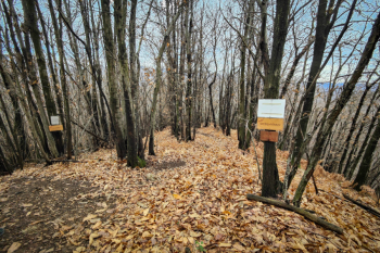
Descent starting from cima la Guardia area. The ascent is very challenging, rideable with emtb, after a short and fun trail always uphill we are faced with two trails, the one on the left is called "Ciaoroby" and we think it rejoins the one on the right (which we rode). The descent is quite fast and steep I recommend doing it only in dry weather. It is an S2 in the woods that I personally was not crazy about (maybe because of the wet period with lots of leaves).

Trail Style: Enduro, Trail
Personal rating: 7/10
MTB: Yes
EMTB: Yes
Difficulty uphill: very challenging,
Difficulty descent: medium S2
Drainage: no, wait for dry period
Local weather
Tonight

20 °C
Tomorrow

33 °C
Tomorrow night

19 °C
Sunday

32 °C
Sunday night

19 °C
Monday

28 °C
Graph
Nearest Routes
4,89 km
Km
+300 mt
Vertical meters
Route difficulty
Landscapes
32,10 km
Km
+1 213 mt
Vertical meters
Route difficulty
Landscapes
48,22 km
Km
+1 950 mt
Vertical meters
Route difficulty
Landscapes
37,89 km
Km
+1 435 mt
Vertical meters
Route difficulty
Landscapes
31,99 km
Km
+1 120 mt
Vertical meters
Route difficulty
Landscapes
32,87 km
Km
+1 200 mt
Vertical meters
Route difficulty
Landscapes
20,51 km
Km
+430 mt
Vertical meters
Route difficulty
Landscapes
31,13 km
Km
+1 463 mt
Vertical meters
Route difficulty
Landscapes
29,49 km
Km
0 mt
Vertical meters
Route difficulty
Landscapes
28,84 km
Km
+1 003 mt
Vertical meters
Route difficulty
Landscapes


 Italiano
 Deutsch
