
 Italiano
 Deutsch
All Star

REWORKED ROUTE! ACCESSIBLE EVEN TO BEGINNERS WITH A MINIMUM OF TRAINING, HAND BIKE, TANDEM AND GRAVEL BIKE*.
The route begins at the Church of Monghidoro. From here you enter the main street of the town and ride along it until you cross the S.S. 65. You turn right, proceeding in a southerly direction for a few hundred meters, and then turn right into Via del Mercato and, after a few dozen meters, immediately left into Via della Pieve. Having gone around the bend, one has to turn left into Via Caduti di Roncastaldo and then continue for a few hundred meters until one locates, on the right, near a pylon, the entrance to a short but fun little path that comes out further on into Via Pian dei Grilli. Continue south along Via Fornace and then Via Cà del Costa until you reach the road that leads from S.S. 65 to Lake Castel dell'Alpi. You take a right and proceed for about a kilometer until you reach Piamaggio.
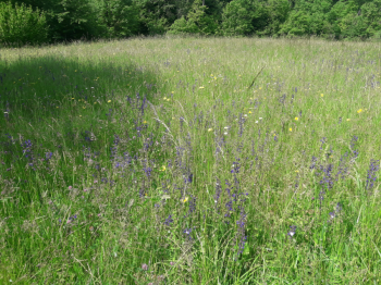
Near the main square, turn left onto Via Cà di Giovannone and pedal through the meadows, splendid in spring for their blooms. After passing through the houses of Fontana Buona and the nice "Bridge over the Kway River," we arrive at Cà de Brescandoli and take a left onto Via Tre Fontane that will take us to Cà di Guglielmo and from there to the beginning of a nice stretch, first on dirt road, then on path, that winds through the woods and that will allow us to arrive near Campo di Roma.
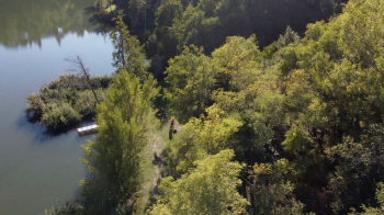
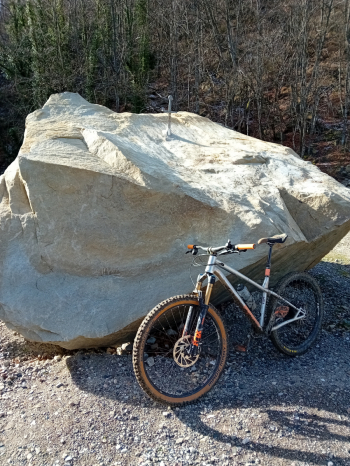
Here we turn right and re-enter the asphalt road in the vicinity of Trappola. We take a left and passing Cà di Pallerino and Tre Pesci we arrive at the bridge that crosses Lake Castel dell'Alpi. Having reached the opposite bank, near a now disused gas station, we turn left and descend toward the lake. After crossing the small bridge, a visit to the "Sword in the Rock," located a hundred meters further to the right, is recommended.
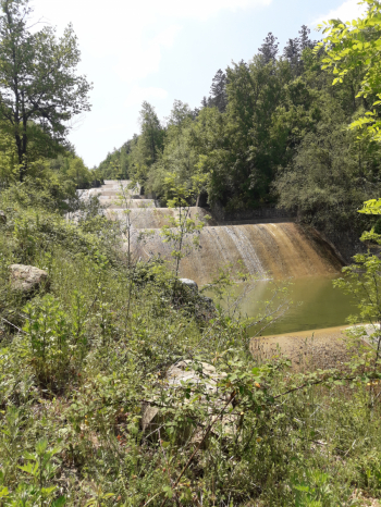
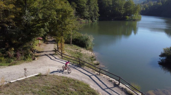
You then proceed pedaling along the right bank of the lake, at first on asphalt, later on the beautiful path that runs along it. There will be no shortage of spots from which to take photos. When we reach the end of the lake, we must continue right, downhill along the gravel road that runs alongside the Savena's weirs and allows us to arrive at "La Porta delle Sindoni," one of the various works that dot the Bom Art Trail. Paying attention to the two chains put askew to prevent access to cars (handbikes will be able to pass underneath, and bikes will be able to climb over), continue downhill to the Mandrullo Mill. You then ascend to the valley floor road near a hairpin bend and proceed at this point to the left, heading north.
You stay on the main road until you reach the junction to Monghidoro. You turn right and climb until you reach the junction for Fradusto. Before a small villa, you enter a grassy lane on the right and continue along the coast through fields, meeting the villages of Valzole and Frassincò. The very scenic route finally arrives at Via Cà del Barba. It climbs again on narrow asphalt until it reaches again the road to Monghidoro. Take a right until you cross, on the left, Via Vaiole. Go downhill until you reach the village of the same name (slow down between the houses!). You cross it and enter another nice dirt road that passes through fields and groves until you reach Cà di Dino, near a hairpin bend. You descend to the intersection with Via Lognola where you turn right and pedal to the intersection with Via Bruscoli. Turn right and climb until you find, on the left, Via Cà de Marchi, which allows us to climb up to Monghidoro, near the intersection with the S.S. 65 della Futa. At this point we turn right and follow the signs that allow us to return once again to the historic center of the town.
*: The route does not present any particular technical difficulties. However, there are downhill stretches on dirt road and path with some uneven spots.


