Italiano
 Deutsch
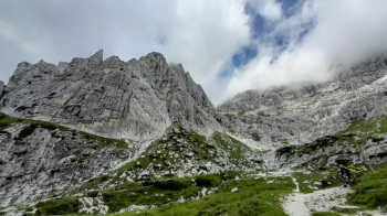
Sella Nevea: Sentiero dei Tedeschi - Rifugio Corsi e Passo degli Scalini

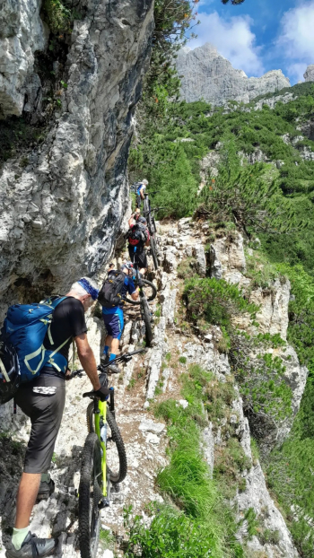
Route with descent on asphalt, very steep ascent to Malga Grantagar, extreme section in which to carry the bike on partly equipped path to Rif.Corsi, spectacular traverse almost all pushing up to Passo degli Scalini, descent on very challenging path in the first part to the woods and then a bit smoother to Malga Cragnedul, short ascent on dirt road and descent on medium difficulty path in the woods.
Starting from Sella Nevea, descend on asphalt to the left entrance (at a wooden signpost) of the road in the woods to Malga Grantagar, partly dirt and partly cemented, very steep to the limit of rideability and breathless until the malga, where the view opens up to the wonderful peaks. We descend slightly again and continue on the Germans' Trail CAI628a downhill to a ford in the first few meters and then completely by bike with some steps, steep and strenuous, with some equipped and exposed sections, very scenic and rewarding. The difficulty remains until the Corsi Shelter, as of today still closed, from which the view is magnificent at 360°. You descend a little until you intercept the trail that climbs to the right on the grassy ridge for the long and almost entirely push-and-shoulder traverse in the same basin, among herds of ibex. You reach the Scalini Pass and face the other valley that gives towards Mount Canin to dive downhill on CAI625, which descends in a traverse dug out on the meadow, with a rocky and steep bottom, also very challenging because of the very narrow hairpin bends. Moving stones and steps undermine in several places, until you enter the forest, where the difficulty decreases slightly. You reach the Malghe road to the Montasio plateau, which you climb for a short while until you intercept the path to the left on a bend heading towards Sella Nevea, which descends into the woods, smoother than the previous one, albeit with some technical points. Long and in places fast it leads to Sella Nevea merging onto a dirt variant of the ascent to the plateau.