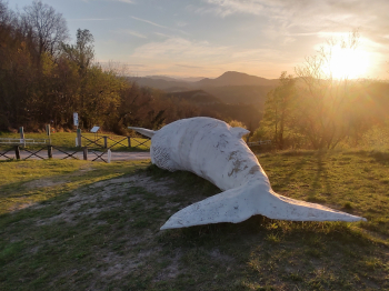
Balena del Farneto
Training ride with a nice, steep descent.
Start in Botteghino di Zocca and climb up via Caurinzano. At the two forks in the paved section you continue straight ahead and climb up to the Cottu Dairy. At the intersection of the dairy take a right up the very intense but short concrete climb. At the top of the climb continue straight ahead ignoring the left fork. At the whale you keep to the right and at the farmhouse you meet soon afterwards you drop into the woods. The trail at this point has only one fork and you should continue straight until the descents begin. At the end of the descent, the trail rejoins Via Caurinzano: left to go back to the car, right to go around again.
Beware of the culverts dug on the trail, some are very deep and dangerous. The descent is very steep in places. Almost all ascent on asphalt, all descent on dirt road and trail. Short loop that lends itself well to one or more laps depending on one's level of training.
I think the route is all in all easy but perhaps not really suitable for beginners: you need to be able to sufficiently steer the bike away from the channels, know how to brake and have a minimum of leg so you don't have to push the bike on the steepest sections.
Halfway along the route is the Farneto Whale:

The sculpture is placed at the spot where a whale fossil was found in the Zena Valley.
Update 03/06/2023: As of yesterday's date, the trail was passable despite recent flooding and landslides. Watch out in a couple of places where the road and trail already came. The landslide on the paved section is clearly visible, the landslide on the trail on the other hand is in the path but in a pedaled section with zero difficulty. The road is closed to vehicular traffic and cordoned off with construction tape.


 Italiano
 Deutsch